
I have found that 10,000 km separates DYNAMICS' FEATURES of the 40,000 km Circumference Earth; this is a Quarter of the Surface Distance- which makes a 90 degree Turn- changing a Vertical feature, e.g. an ERUPTION into a Horizontal, or Lateral movement along the Crustal solid rock (called a TRANSFORM FAULT by Geologists)!
Above Arc from the ORB of South America to the Equator is a first trial- shown in multi-colors above ^.
Below is a reworked Version:

New informaton on the 10,000 km Earth Quarter:
a LATERAL quake > < makes a sideways FAULT SYSTEM, where a horizontal movement is associated with a Vertical ^ or Down path into or out of the Crust of the Earth (up ^ is an Extrusion or an Uplift), and a downdrop may be GLACIAL SPALLING or Rocks falling over a Scarp, or Segments falling into a Trench. These will be shown with case histories!

Tonga Trench, TT, is associated with Colima Volcano above, and below is Hawaii 10,000 km from Iceland:

Antarctica SPALLING is shown below- associated with the NE Sumatra 6.5M quake:

Cases have shown that Google Earth path takes the shortest path (through the Quarter of Earth, or 10,000 km) and it will not pertain to the surface hard rocks- as Rayleigh waves take), so a 45 latitude shift in the "Juts" of North and South America, at Mendocino, CA: 40.439N and Talara, Peru at 4.561S will not result in a meaaured Hypotenuse of 7171 km- but 300 km shy at 6870 km! 45 degrees is 111.111 km x 45= 5000 km between Latitude parallels. Difference reflects the SHORTER PATH through the deep crust!

Google Earth South America Westernmost Jut:

Talara, Peru Jut is to the SE 45.1 degrees of Latitude change:

Total change is 45.1 degrees, and this .1 may be due to ineptitude!
SUMMARY: the North American QUADRANSPHERE is a Quadrant, only for the LATERAL EXTENT! 10,000 km (Quarter of the 40,000 km Circumference) is the Separation at a constant COMPASS ANGLE, from Hawaii to Iceland (both HEAT ANOMALIES).


Above is the Northern Hemisphere, divided by the DARK BLUE LINEAR, which has a LENGTH of 4000 km, (EXTENDING to the south, as the MAR opens the Arctic at the Gakkel Ridge):

The LARGEST FEATURE that can be Measured by Google Earth Earth on our QUADRANT is a LaGrange equilateral TRIANGLE, which measures 16,000 km on its SIDES. It Starts at a CRATON, at Hudson Bay, and extends to the Australian CRATON:

16,000 km SIDE Slices a Figure 8, shown in RED and PINK, Indicating PROXIMITY to the Correct DIRECTION!

Hudson Bay is at CRITICAL COORDINATES 60N, and is the EQUILATERAL TRIANGLE CORNER for the Array of STABLE CRATONS! The third CORNER is at 16,000 km/111.111 km/degree Latitude)= 144 degrees= (60 + 84) CHANGE or at Antarctica 84S:

Hawaii to Iceland forms a 10,000 km TRIANGLE, and the 60 degree EQUILATERAL relates to the Maui TRANSFORMS, where a transform "jerking" is associated with a 10 Kkm distant Volcano- which erupted previously:

MAR is dark, aligned by pink lines:

to Bardurbunga:

LaGrange EQUILATERAL Triangles are Part of the PACIFIC Sun's 7.2 degrees Latitude SEPARATION of the MAJOR TRANSFORMS (along a Meridian)!

Literature has 7.25 degree Sun TILT, and there is PRECESSION!
ICELAND:
 \
\
Iceland is an island which is Expanding E-W, but which is at a Stationary latitude, and as EARTH TIDES are continually moving- this creates Heat of Gravitational Friction! LaGrange solved this 4 body Equilateral Triangle case created by "Hilda" asteroids, Jupiter, our Moon and Earth- and this is transferred to Iceland wnen orbiting concentricly via the MAR, seen at the SW Corner (shown via the earthquake.usgs.gov in the photos)!
Age of the Initiation of the "Slices" of the 1500 km Transform yield near 100 million years, and I will determine if this is a Precession cycle of our Sun's tilt?
NOTE: 10,000 km is a quarter of the circumference (90 degrees/360), and its Dynamics creates a Vertical ^ at one end, and a Lateral transform (Horizontal) > at the other; vertical can be Volcanoes or Scarps downward, while Lateral can be in either direction < or >. 10Kkm may have a Quake at one end, and a Volcano at the other (starting with 6.5M and "Killer" Volcanoes)!
MEASUREMENT from Hawaii to Gulf of California is 4750 km/75.89d at 24N 108.6W (61E of Natural Prime Meridian), which is a SIDE of a LaGrange TRIANGLE, with 16,000/4750= 3.368 ratio.

LARGER REGION, I expected to get info about the Great fault separating Mexico from Baja- but this case is Not solved::

Above pink line shows the CREATION pf the Gulf of California LINEAR (Sea of Cortez), from the LaGrange TRIANGULAR Relationship! NE Side:

ENTIRE TRIANGLE:

ERROR of 100, between the 2 North lines, km is due to incorrect Starting point; it should be on a Longitude on the Big Island:
 \
\
Re-working:

CASES indicate that Pacific TRANSFORMS are partly LOCATED at LaGrange STABILITY ZONES:
Small scale example of Sullivan Knoll, Hurricane, UT:

Requiremaents for CONSTRUCTING a LaGrange EQUILATERAL TRIANGLE:
1. EVEN-NUMBERED Ratio of 10,000 km/Transform side, e.g. 10,000/3.33333= 3000, for this case;
2. A LINEAR TRANSFORM to guide one STRAIGHT LINE side location;
3. HEAT GENERATION at one end, and an ANOMALY at the other.
Sullivan Knoll is a young, poor, Eroded example, but it is NEARBY

NOTES about LaGrange TRIANGLES:
LaGrange determined the Relationship between Solar Masses (Planets and Asteroids) and Adjacent Bodies which are Gravitationally POSITIONED in a TRIANGULAR Configuration to each other. There are 5 points to a 3 Body Solution, and they are Labelled as follows:
1. is the Point of Coordinate STABILITY, which produces HEAT of slicing (Vulcanism on a Large Scale, Hot Springs on a small scale), such as Iceland;
2. is a Balanced Point, between two Large Masses;
3. is a point determined by the Barycenter of the Large Mass;
4. and 5. are on Sides of the Triangle, with STABILITY, approaching a Corner of INSTABILITY! This determines the Point of Drastic CHANGE!
CASES may allow a UNDERSTANDING of this Phenomenon, such as Ayers rock in Australia:
It is now apparent that there occur many SCALES, and the smallest investigated is found in Outcrops of the VIRGIN ANTICLINE, Washington City, UT in Jurassic Navajo sandstone Jn:

The WATERWAYS of the EARTH are arranged in PATTERNS, such as the Major Lakes- which are exhibited at FRACTIONS of the 90 degree half HEMISPHERE! Examples are the LARGEST Lakes at 44 to 45N Latitudes, and 12N for Lake Nicaragua, the Zero Meridian Equator for Lake Victoria and the Amazon basin.

GRAVITATION and
LaGrange Mathematical Relationships:
The LARGEST LaGrange 2Dimensional TRIANGLE found on Google
Earth has SIDES of 16,000 km, and this Fraction of .4 = 1/2.5 of the Earth’s
Circumference is the Largest possible, since those larger than 19,999 km cause
INSTABILITY and impossibility of use of the Measurement tool! The RATIO of 2.5 refers to a Mass
dependency, e.g. Jupiter’s mass is that ratio to all the others in the Solar System
(excepting our Star- the Sun).
LaGrange EQUILATERAL TRIANGLES (with all Corner angles of 60 degrees, and ALL Sides of equal Length), has been solved,
mathematically for the 3 Body Case, where the Earth, Jupiter, and a Third
Satellite (Natural or artificial) are Placed in Positions of STABILITY,
Instability, and relation to a Barycenter, or three quarters of the Earth’s
Radius, in relation to the Moon’s Offset= 4600 km from Earth’s Center.
Barycenter of the Sun is also inside that Star, and these are named Point 3 by
LaGrange. The Point of most Interest to Earth is Point 1, and it is displayed
at Latitudinally-Stable Iceland, creating Heat of Vulcanism to maintain its Stationary
Location (while extending laterally, E-W with time)!
Points 4 and 5 are Stable Linears or Transforms, and may
be viewed on the Iceland TRIANGLE at a line stretching from England to the SW
Corner, after which there is approach to Iceland along a Linear which measures
the LENGTH of a Side.
 Above TRANSFORMS indicate that a TRIANGLE can be formed with the last WESTWARD TRANSFORM (along the MAR), and at a precessing 55N Longitude:


"BIG Picture" shows a possible LaGrange TRIANGLE at the western edge of the WIDE TRANSFORM BAND (indicating both "CREEP and JERK")!
Bardurbunga Photo:

NW corner of Iceland is 16 million years, and the younger is to the East.


Age and Analysis of 10Kkm separations:


TRIANGULAR Relationships for more than 3 Bodies
are COMPLEX, and
will be solved by cases, first involving Venus, for the 10,000 km sided
Triangle, and which calculates 16,000/10,000= 1.6, the IDENTIFIER for
Venus (near Earth days/Venus days per orbit. This calculates 1.625= 13/8, and
there is a Variation of Venus’s orbit to accommodate this (possibly). This case
was solved first, as the Triangle from the Red Sea, 1.2S Latitude and the North
Pole. It is LARGER than the Iceland Triangle, and assumed to be OLDER in
formation!
The next ENTITY is
that of DIMENSIONS, since the Comparison of Venus and Jupiter
notes Mass Ratio vs. Orbital Ratios! Venus is Not in the same System as
Jupiter, where 16,000 is divisible by 2.2222, yielding 7200 km and its Exact
Fractions of 3600, 1800, 900, 450, and 225. These are the lengths of Sides of
Triangles, which are expected to occur at Critical Coordinates on Earth. Venus
triangles are expected to exhibit sides of 10,000 km and its exact fractions
(Harmonics).
This Categorization reveals that the 2.16
ratio of Moon/Sun, is NOT INVOLVED, and requires that the Ratio: 16,000/2.16=
7407.407407 be investigated! It may be that the Influence of Mars has offset
this Difference between 2.222 and 2.16!
Mars must be Incorporated into this ANALYSIS,
and it should fit the Ratio: 16,000/1.88= 8510.6 km. This is the NEXT Category
of Triangles.
SCROLL DOWN to see the WEATHER Photos and their SIMILARITY with EARTH TIDES. Venus is influencing our WEATHER:

Veuus VORTEX:

ENLARGED::

CW Spiral at the SOUTH POLE for RETROGRADE Venus means RISING ROTATION and Closer to Earth, yielding INCREASING ATTRACTION for Aleutian HIGH DENSITY COLD Air Masses and SLINGING towards Continental USA to the SE-ward!
MORE on ATMOSPHERIC TIDES halfway down the BLOG!
The 44 to 45N line of Lakes continues across Europe to Asia:

Tracing EASTWARD along the 44 to the 45N Latitude Parallels:

There is an ELLIPTICAL ARRANGEMENT of Lakes, and this will be pursued LATER!
Here’s how UPLIFTS (Rises) and Basins (sinks) are formed, including their relation to an ANALEMMA:
1. While all Planets move around the Sun in Elliptical Orbits, ALL of them exhibit Inclinations to the Ecliptic plane; these small angles allow the Planets to individually Gravitationally Attract portions of the Earth’s Crust, when they orbit BEHIND the position of the Sun. This attraction creates UPLIFTS, according to their Mass/(separation from Earth) squared.
2. During this elliptical orbit, at least half of the Time there is Lateral movement somewhat PARALLEL to Earth’s orbit; this creates SHEAR;
3. During CONJUNCTION of Sun and Planet, there is combined attraction, creating Basins on Earth next to Uplifts which had been formed when the Sun and Planet were in OPPOSITION;
4. All Planets create this Rising and Sinking (with some BODIES interfering with others); this creates Elliptical COMBINATIONS, where rises and sinks may be ADDITIVE or they may OVERLAP; and,
5. Additive ADJACENT movements yield a side-by-side set of ellipses, which in the simplest case is a Figure 8, with a ratio of diameters of the ratio of days of Earth Orbit/days of Planet orbit, which in the case of Venus is 1.62. This Figure 8 is an ANALEMMA, with a ratio of diameters or Foci dependant upon the Planet and its separation from earth and its Mass squared:

Artificially constructed over a year of photos"

My CALCULATIONS from case histories yields a RATIO of 2.16, for the two DIAMETERS. This is being AVERAGED for seven cases, and varies from 2.10 to 2.195!
Another FUNDAMENTAL Feature to be incorporated in Earth Tide analyses is the "HOLE" and Slice phenomenon, which is illustrated for a Sand Mountain, St. George- Hurricane, UT area feature found in the bottom of a Wash:

Introduction to the North American Quadransphere, Qsna
Qsna is shown on Google Earth as an ELLIPSE, extending from the Hawaiian-Emperor SEAMOUNT chain E-W to the Mid Atlantic Ridge, MAR. It is divided by the Wasatch Line, a N-S FEATURE

Wasatch Line separates the younger Basin and Range from the elliptical Colorado Plateau, CP,

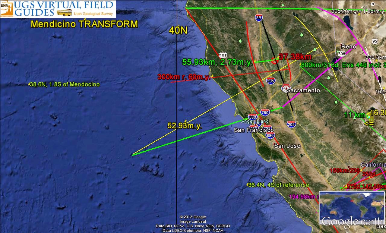
and it is further REFERENCED to the Mendocino TRANSFORM, CA (approximately at 40.439N latitude):

ENLARGED:
Latitudes for Hawaii are near CRITICAL FRACTIONS (180/36= 5; 180/20= 9. Longitudes are near the 49.6W, or 120E of the Prime NATURAL 169.6W Meridian, and 154.6W or 15E of Prime:
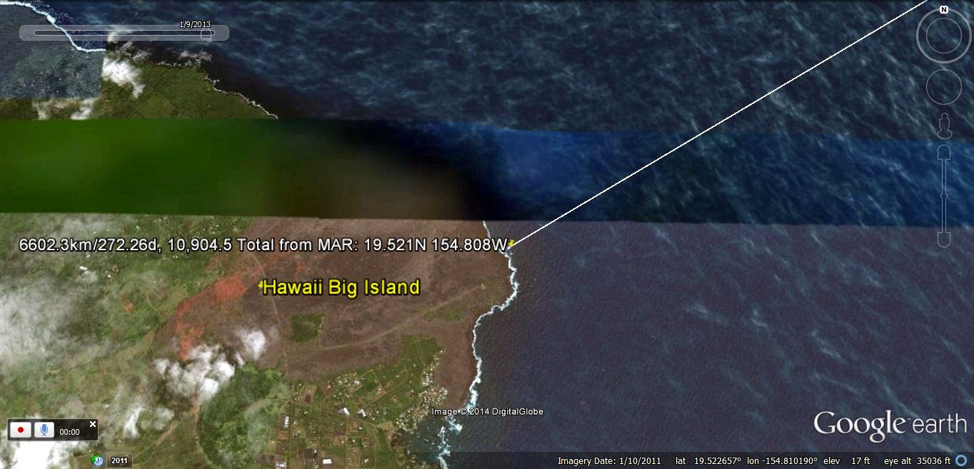
The RATIO of the two separations yields INFORMATION about the Solar bodies which created the EXPANSION. The ratio= 6,602.3 km/4302.2= 1.5346, and approximates the Moon's Constant OBLIQUITY to the Equatorial Plane (6.688d)- 5.145 degrees of Incliation to the Ecliptic PLANE= 1.543, with .125% variation (error due to my imprecision in making the MAR starting location)!
This is APPROXIMATED by the below WIDE VIEW of 10,000km:

Earth in 3D is only approximated with a 2D map, and ANGLES must be measured from a Constant Start Location to be Useful!
Shown are 10,000 km distance Measurements from the SHORTEST Great Circle route:

Mauna Kea, HI big Island:

The distance from the MAR to Mauna Kea is shown above, and it relates to the OLDER EXTRUSION; now, the distance to Loihi, the YOUNGEST, is farther. Taking Mauna Kea, the FRACTION of the Circumference of 40,000 km is 25 percent. Considering that degrees and ratios have NO DIMENSIONS, and that Venus is our closest influence, excepting the Moon, the RETROGRADE Venus may have some CONTINENTAL Gravitational attraction for the Qsna (North American quadrant).
HEMISPHERIC VIEWS:
Other case histories may be found in: www.PorOgle.blogspot.com
North American QUADRANSPHERE, Qsna, is an ELLIPSE which has EXPANDED more to the north than to the WEST.

North American QUADRANT is divided at the Lomonotov Ridge
Qsna- the 10,000 km separation of Hawaii and Iceland is a quarter FRACTION of the Earth's 40,000 km circumference- is an ELLIPSE, extending North and WESTWARD wih time.

Cases have shown that 10,000 km separates an active Volcano and a Quake greater than 6.4M (Quarter of the 40,000 km Circumference of the Earth), and this "twist" results in a Vertical Extrusion on one end, and a Lateral (Horizontal) Transform "jrtk" on the other!
The PATH on the west side extends from the Beaufort Sea in an ARCUATE development to the Hawaiian-Emperor Seamount chain, with a DIVERSION at the Aleutian SPIRAL (another important Analemma Reference), which was scribed from 80 to 41 m.y. ago.
Arctic as seen, divided by Lomonotov Ridge:

Greenland Ridge to Lena River:

You may notice that Google Earth exhibits ARCUATE Figures, and these are usually separated by Rivers (which underlie many FRACTURE line ARCS). Arcs are really sets of adjacent LINEARS, sufficient in number to appear as arcs!
Solar System INCLINATIONS, MASS, and IMPORTANCE of (i/d squared) x MASS:
Body Perihelion P squared, Incline MASS ratio; (i/P sq.) x Mass
Moon:.0496x10exp6 km; .00246; 5.145d; .0123E;M(I/Psq)=25.725
Mercury46 x10exp6; 2116, 7.001, .055 x E= .000182= 1/5496
V: 107.5 million km: 11,556; 3.39d; .815; .00024= 1/4183
E: 147.1 (subtract V to find CLOSE SEPARATION); mass = 1
Mars: 206.6 x ; 42,684;1.8; .10744 x E; .0003925= 1/220,710
Jup: 740.74x; 548,696; 1.305d; 317.82x; .0007559= 1/1323
Sat: 1,349.5x; 1821150; 2.484d; 95.16x; . 0001298= 1/7704
Uran: 2735.6; 7483507; .77d; 14.371x; .00000148=1/675676
Pluto; 4436.8x; 19685194; 17.14; .0022x; 2 x 10exp-9, insignificant
Ceres: 381.4x; 145466; 10.58d; .00016x; 1 x 10exp-8, insignif.
Above MASSES, etc; IMPORTANCE by SMALL ratio (Moon Solar System
Above MASSES show IMPORTANCE by SMALL INVERTED ratio (Moon 1st, Venus retrograde, as is Uranus)
North of the ARCTIC CIRCLE at 66.563 North Latitude, there is a SEPARATE REGIME- where the Moon controls the 40-41 m.y. 3.6 degree SHIFT, rather than Venus! This RATIO: 5.145/3.6= 1.429, creates a NEW MOON LINE!

Although the DIAGONAL LINES are part of the SOUNDING or photography, the ANALEMMA is NATURAL:
Chukchi Plateau is a RISE, follow the Qsna PATH:

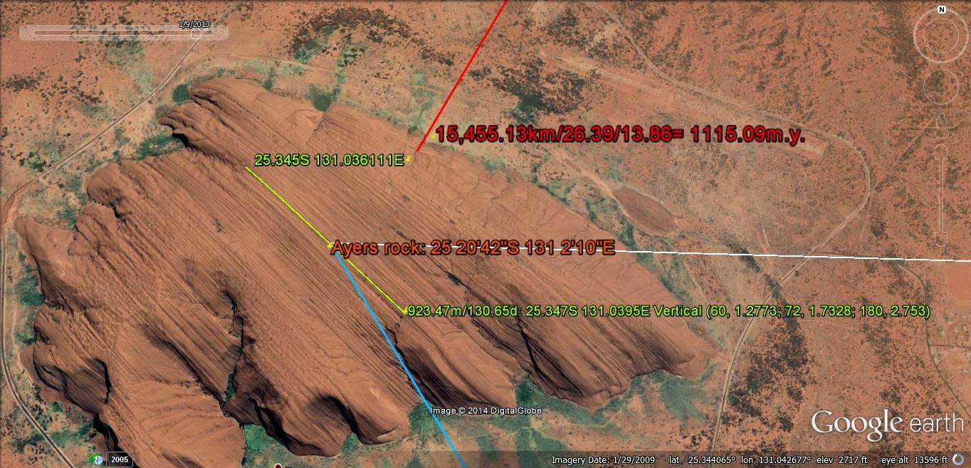
Compare Qsna to the 4096+ km wide Australia continent, where Ayers Rock lies 2048 km from the east coast Precessional feature:

Ayers ROCK has STRATA (lineations?) tilted 85 degrees from Horizontal, at 25.345S 131.036111W, with a height of 813 meters for the Cambrian ARKOSE from nearby PreCambrian hills:

This relation of MEASURED FEATURES to the BINARY THEOREM is TESTED, by finding the ERROR DISPLAYED at the east coast of Australia; NOTE that the error is less than 1% of 2048km, HALF of the width of 4096 km:

North part of Qsna is a half FIGURE 8, which shows that Alaska becomes a "TIT" off the NW corner (notice the ARCUATE Aleutian Chain and the movement to Mt Elias- a HALF CIRCLE inside the TIT). This initiates the TRACK of the HI-Emperor SEAMOUNT CHAIN- which is the trace of the ELLIPSE since 80 m.y. AGE:

Below is exhibited a HALF Figure 8- which Scribe at least as far north as 64N, or to the Great Slave Lake:

IMPORTANCE of the NUMBERS, RATIOS in the BINARY THEOREM:
These should be MEMORIZED, since ALL of value to the EARTH DYNAMICS are shown by AGES, LINEARS, ARC FOCI, and ANGULAR SHIFTS in the SERIES: 2, 4, 8, 16, 32, 64, 128, 256, 512, 1,024, 2048, and 4096 km or m.y. and their HARMONICS, such as 10.24, 20.48. 40.96, or 1.024, 2.048, 4.096, or 10.24, 20.48, 30.72 degrees in a TRIGONOMETRIC DIAGRAM:

The BINARY THEOREM relies on NUMBERS and mathematics, which are easily remembered, for MEASUREMENT and PREDICTIONS of the Dynamics of the Earth's Crust!
There are HARMONICS included, so that at least ten sets of associated numbers are REFERENCED: 2; 4: Byam Martin million year AGE; 8; 16: AGE of Columbia flood basalts- 16 m.y.; 32, 64: KT event (Cretaceous Tertiary boundary Chicxulub event); 128; 256: PTr (Permian-Triassic extinction in m.y.); 512 m.y. age of Burgess Shale; 1024 m.y. age of the grand Canyon Great UNCONFORMITY; 2048; and 4096 m.y. age of the INSTIGATION of the sequence.
Second harmonic= 1/100th: .02, .04, on to 1.28 and 10.24- the TIDAL RATE of the Solar System. Continuing, on to 40.96, yields Milankovotch's AXIAL WOBBLE cycle in kiloyears, k.y. and the Polar TILT ANGLE shift at 40.96 million years, m.y. This has an associaed DISTANCE of 400 km and 3.6 degreees or 1/100th of the Earth's CIRCUMFERENCE!
1/1000th: .002, .004, on to 1.024- which is the most useful INDEX for the Earth, where the Continents EXPAND at a yearly rate of 1.024 mm/year-yielding a CIRCULAR East to west ORB diameter of 4096 km for North, South America, and Australia (errors less than 1%, since starting age 4096 m.y. ago)..
NEXT will be introduced the Hole-Splice phenomenon, which is the START of Gravitationally-determined SINKS having an ASSOCIATED Linear through the sink (shifting with Time to the periphery, to form a RATIO of distances from the edges), shown for the small example found in the Zion NP, on the pools Trail:

Above is COMPARED with a SINKHOLE in a karst region:

Two SIGNIFICANT GRAVITATION-ALLY-related features occur, which sheds light on the Evolution of the Hole into a LARGE BASIN, and the INVERSE rise into a Plateau:
1. The SLICE through the hole SPREADS ORTHOGONALLY, creating a WIDENING CHANNEL, e.g. which Geologists recognize as a Drainage Path through an ANTICLINE (for the Rise), and a RIDGE for the Basin;
2. The Ridge or Channel splits the Feature in two parts, with the Ratio becoming LARGER than 1.0 with Time! It attains the Largest value for CONTINENTS, e.g. for the Mississippi River splitting the Continent along a N-S AXIS! This was shown for Qsna, with 1.543 ratio (which is a CONSTANT relating to our Moon's { Obliquity- I}= (6.688- 5.145 degrees).
Other MOONS of Jupiter and Comets which act temporarily as moons (Shoemaker-Levy striking Jupiter in 1994, from a DIAGONAL ORBIT about Jupiter, making it Moon-like); these operate on reduced SCALES, so that the ratio varies, according to the Mass and distance squared!

Io above is Jupiter's LARGEST Moon, and below is the next in Size:

Europa above, and Ganeymede below:

Our own Moon can be DIGITALLY-photod:

ALL of this is to DEMONSTRATE that Continents were initiated as Anticline-like STRUCTURES, which split inside, forming a SLICE through a RIDGE (which is a Continent with a Central Drainage SYSTEM)!
The RISE and accompanying Drainage SLICE starts with the following small Feature- a Mima Mound, with a depression in the middle. This CASE shows the Half ELLIPSE Arrangement of Individual Mounds:

A visable SLICE through an individual mound is rare for soft soil (constant shearing creates good soil and capillary action); below is one which demonstrates the result. These are less than the AGE of the last Glaciation Age of 15,625 years:


Glacially-borne EXOTIC, below, lies atop a Mound, indicating that it PRECEDED the Mound (Moraines would NOT drop on top of an existing hill). Fractures are ORIENTED 150-330 degrees by GPS Compass (True bearing). This is also the orientation of sinks in Harbor Golf Mima Mound arrangement. This establishes that the AGE is less than 15,625 years- the Last GLACIATION advance:

CROSS-SECTION is shown for one excavated for Road Gravel:

The MOUND grows, as its base ERODES; this is seen for the Checkerboard Mesa in Zion NP:

The SLICE, above, orients N-S, and has been distorted by subsequent EVENTS. Checkerboard Mesa illustrates the Height GROWTH, as erosion proceeds at its FLANKS! It is near 40,000 years of AGE- the Milankovitch Axial Wobble CYCLE.
Meteor Crater, AZ, is a COLLAPSE FEATURE, formed by the Moon's ORBITAL Inclination ANGLE from the Ecliptic Plane of the Sun:
EQUATION (360 degrees-x)/x= Inclination angle of 5.145, yields x= 58.5842148 degrees from the Prime NATURAL Meridian. This Prime is the SEPARATION of the NA Continent from Asia at 169.6W longitude, at the Diomede Islands. Finding the location referenced to the Greenwich Meridian is a subtraction= 111.01579W- which is the longitude of Meteor Crater. This is NEAR 111.1 degrees, within the ACCURACY of the measurements (3 significant figures, at most). This is also the number of km/latitude degrees, from 180/1.62 (Venus ratio of days/earth days, 81/5 or 365.24/225.46)= 111.111, and the RATIO of 40,000km/360 degrees= 111.111km/degree of Latitude! This shows how the DYNAMICS of the Earth is related to the Mathematics of Derivitives!
Meteor Crater is a SINK- which fits the finding that circular HOLES are arranged along a N-S LINE by LATERAL GRAVITATIONAL shear. There occur several SINKS along the Mogollon Rim in this vicinity. Lake Stoneman, AZ:

This is shown by the Google Earth view for the Meteor Crater ROUND FEATURE:

Expanding:

Also of interest is the Crater Latitude of 35.016N, which is near 360/10.24= 35.15625 degrees (measured at 360/35.01= 10.28, with my normal engineering ERROR). The ratio 10.24 is another CRITICAL NUMBER for the stability of the Earth, within the GRAVITATIONAL SYSTEM!
The 3 cell MODEL is introduced below, to have an easily-remembered diagram for COMPARISON of field features to a UNIVERSAL MODEL:

Below is the Focus of the New Madrid EVENT (Notice the Partial Figure 8, for the Mississippi River PATH, which does not proceed South with time, as do most meanders);

EXPANDING:

WIDER VIEW of the River:

YELLOW LINE is the N-S REFERENCE from Chixculub, Mexico to Hudson Bay- approximately at 89.6W Longitude (on which the Mayans constructed their most SACRED TEMPLE: TIKAL).

EXPANDING:

The BASE of the BINARY THEOREM is 1.024, and this exhibits MULTIPLES of 10, 100, 1000, up to 1 billion (1024 million years- the GREAT UNCONFORMITY of the Grand Canyon).
NOTE: The ANALEMMA is displayed in many ANOMALOUS locations, as a Partial Figure 8, seen in the Virgin River (beside Hf, the Hurricane Fault):

Above CONTRASTS with the Virgin BEND, where it crosses the ANTICLINE at St. George dam:


SUMMARY: QUADRANSPHERE.
The Qsna ELLIPSE, which is a shearing rotation surrounding North America, is forming by the combined GRAVITATIONAL ATTRACTION (BOTH LATERALLY and VERTICALLY) of the earth-moon-Solar system. The rate of RETROGRADE movement is 10.24 km/m.y. (in the exact 90 degree EAST Compass bearing!
MARS INFLUENCE on the Crust:
MARS and its 1.88 year ORBIT scribes a N-S line through Greenland (20,004.29 km Pole to Pole):
The days/orbit of Mars/Earth year= 686.65/365.24= 1.88 RATIO. Using in the EQUATION: (360 degrees- x)/x yields 360/2.88= 125, which SUBTRACTED from 169.40' yields 44 40' or the Longitude of the CENTER of Greenland (235/125= 1.88, and 169 40' (the Greenwich longitude of the Diomede Prime NATURAL Meridian) minus 125= 44d 40'N= 44.666667N.
Greenland south:

Greenland south coast to MAR at 15N Latitude, ABOVE ^.
This MERIDIAN and its associated ANOMALIES may be added to the Mars INFLUENCE on the Earth's Crust, as a REFERENCE to find the IMPETUS of unknown ARCS and LINEAR CONFIGURATIONS.
MAR Mars 44 40W

Above, the Mars Meridian is shown at the INFLECTION at the MAR 15N Latitude. Below is shown the expanded ANOMOLY (Analemma and Ice melting on the South coast of Greenland):
and on the North Coast, associated with the Gakkel active Ridge:

(BELOW is a photoed artificially-constructed PATH of the Sun, throughout a year, forming an ANALEMMA-Figure 8:
.jpg)
The WOBBLE of the POLES and EARTH TIDES create noticeable influence on the larger, as well as the smaller traces found in rocks, regions, and continents. This results in shearing and rotating cycles, such as those found by MILANKOVITCH (25, 41, and 100 kilo-years). There are harmonics to these, and they are found to be due to the 1/10th up to the millionth ratio, in the series of multiples of two: 2, 4, 8, 16, 32, 64, 128, 256, 512, 1024 million years, up to 4.096 billion years- the age of the INITIATION of the GRAVITATIONAL INFLUENCE of the Moon. THE 10th RATIO CONSISTS OF THE NUMBERS 20, 40, 80, 160 YEARS, etc. and is pertinent for small quakes. A test for field observations occurs with the Earth days/Venus days in an Orbit, RATIO 1.62= AXIAL/PRECESSIONAL DIAMETERS for structures viewed from GOOGLE EARTH, such as the division of the Colorado Plateau from the Basin and Range, at the WASATCH Line:

The circular features are flat (e.g. shown with LEVEL formations for the Colorado Plateau, CP), the precessional cells are tilted with simultaneous extension (Basin and Range), while the elliptical enclose or define the two smaller cycles (the duo of the combination, called an ANALEMMA, or an ellipse if COMPLETED. These combinations are found on the smallest level, as in rock outcrops, up to the largest features- such as the continent of Australia- where there is a “WASATCH LINE” separating the two cells or cycles (near halves, RATIO= 1.62).
The RATIOS of Planetary ORBITAL TIMES, or days in an orbit around the sun, is shown below, and it is a GRAVITATIONAL FEATURE DETERMINING the Ratio of AXIAL DIAMETERS/PRECESSIONAL ROTATION DIAMETERS in an identified ANALEMMA, or Figure 8:
 THE DEPICTION OF Venus in the SOLAR SYSTEM HELPS EXPLAIN WHY THE RATIOS OF AXIAL/PRECESSIONAL ROTATION TIMES OCCURS MANY TIMES AND IN SO MANY PLACES IN MY ANALYSES. THE RATIO IS 1.62, IN THE BINARY SYSTEM (40.96/25.28 k.y.) REGARDLESS OF THE SCALE. Venus is the most IMPORTANT Solar mass, after the Moon, since it is CLOSEST and RETROGRADE (rotating CW, reverse to others) and exerts a LARGE Gravitational Attraction to Earth. Its ratio of Earth days per year/Venus days per Orbit= 1.62.
Introduction to the "NEW WEATHER PATTERNS":
Global Warming and El Niño in 2016 has brought NEW CONFLICTS! What remains that we knew before?
A. High pressure- Clear Skies have higher Density, with less water vapor; mass rotates CW- counterclockwise in the Northern Hemisphere;
B. LO pressure clouds can be seen to rotate CCW, low density-since H2O has 18, and Air has 29 molecular weight;
C. Jet Stream has Large Sinusoidal Cells guiding the smaller LO cells; and
D. WEATHER is "Connected" in the Quadrant-10,000 km, with that at Britain influencing the USA East Coast cells.
Memorize these RULES, and review:quadransphere.blogspot.com
EarthSky indicates that our Sun is heading towards the Star Vega (of my Navigation TRIANGLE: Deneb, Vega, and Altair). Let's sort this all out, since there is NO REFERENCE agreed upon by Astronomers! Our Solar System and all of the Planets are rotating CCW (counter-clockwise), so that our Solar Plane of Rotation is agreeable. I have found that a TILT of 45 degrees has an ORTHOGONAL movement to that of the the Plane of Rotation, so that the Solar Tilt of 60 degrees to the Galactic Plane will have "Look up and see it" rotating CW! This is good news for the Black Hole boys, since a CW rotation means "SINKING"! CCW, or Rising would indicate no black hole!
Sinking of our Galaxy has some meaning- more (at the Center of Rotation- the "Black Hole") than that of Up and Down- which is not meaningful for our Galaxy!
Another feature to "Sort out" is the TIME INTERVAL (not age) for the Sun's Orbit around the Milky Way. which is variously reported as 200-225 million years (a Cosmic year). This can be compared to the Geological record- where the Permian-Triassic boundary (PTr) is "accepted" at 225 m.y. I have it at 256, using the BINARY Numbers and the Quartering Librations of the Moon, and a MASS EXTINCTION is accepted at 252 m.y.- by Geologists, and as the Permian Orogeny by me! All of these features indicate a MAJOR CYCLE, but why does it have to terminate NOW? All of these NUMERICAL EVALUATIONS "tail off" at the present Time (Not an age, but a TIME INTERVAL)! Again, we're stuck with "the Dawning of the new Age of a Queer-iness"!
Geologists are Not comfortable with Measurements, so let's start over- with SUPERNOVAE, Vega in the West, Andromeda's Clues, and Dinosaurs to Man as a NEW CYCLE!

ALEUTIAN SPIRAL, above, HAS THIS RATIO OF DIAMETERS IN ITS CONVOLUTIONS, AND I HAVE A HAND SAMPLE WHERE THE SAME ARCUATE FEATURES HAVE THE 1.6 RATIO OF DIAMETERS.

THIS PORTRAIT OF RATIOS OF THE YEARS REQUIRED TO ORBIT THE SUN GIVES SOME INSIGHT INTO THE IMPORTANCE OF GRAVITATIONAL INFLUENCES ON THE EARTH- AS TO HOW IT AFFECTS THE STRUCTURAL GEOLOGY.
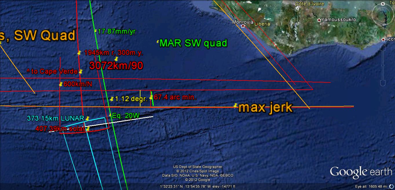
The circumference of the almost spherical earth is 40K kilometers (times a multiplier, to form the ELLIPSE, or PEAR-SHAPED Earth), for CONTINENTS in an E-W ORIENTATION). At least 10K km of this (a quarter of the Circumferance, but a smaller fraction of the earth’s surface) is mapped from the Mid Atlantic Ridge inflection to an anomalous arrangement of seamounts and shear zones, which I call the Kimmei angular SHIFT. This feature is east of the Kimmei seamount (which has been measured for geologic age at about 41 m.y. (the POLAR Shift ANNIVERSARY- notice the large angular CHANGE there) and is an arcuate presentation along the Mendocino Transform). This transform is initiated at Mendocino, CA near 40.439N latitude, and the influence of it may be found across the USA, from the almost E-W arrangement of the Uinta Mountains to Long Island, NY.
Below is the Mendocino transform, which is the PRIME REFERENCE for our QUADRANT. It occurs at 40.439N latitude at the EXTREME WESTERN EDGE of the continental landmass. I will later show that Alaska is a late PROTUBERANCE (tit)- which has risen to the NW, as a TRAPEZOID which can be measured as having 4 sides with 1777.77 km each:

Green Lines are 1777.77 km, and create a Pseudo-Ellipse about Qsna, the North American Quadrant:


This 1777 km distance is a HARMONIC of 1.777- the ratio of 512/288, where (512 + 288= 800), which is found from the COMMON LINEAR DIVIDER 800 km (also for 1024/576, for a 1600 km segment, where 1024 + 576= 1600), etc. for 2400, 3200, and 4000 km- the largest possible CONTINENTAL ORIGINAL ORB DIAMETER). There is an EQUATION for all possible 800 multiples (the equivalent of 7.2 degrees of LATITUDE), which is 1/50th of the EARTH CIRCUMFERENCE. It requires a negative exponent for smaller SEGMENTS, so that all possible MULTIPLES can be incorporated: (1/2) exponents -2, -1, 0, +1, +2, +3, etc.
The transform does NOT remain at 40N, going WESTWARD; it is a CURVILINEAR, and NOT a true LINEAR or LATITUDE PARALLEL (it decreases in Latitude as it proceeds to the west):
An example of another USEFUL CURVILINEAR is that along the HI-Emperor Seamount chain- which displays Midway Island (27.7 m.y. AGE) at an INFLECTION in the trace (a change of COMPASS ANGLE at 2 SEGMENTS' Border):

Let's check Australia- a CONTINENT 2048 km from Ayers Rock- the CENTER, about which the continent is ROTATING:

A difference with Qsna is the Vertical layers (FRACTURES?) in Ayers Rock- which elsewhere creates TERRACES- showing the TWIST or direction of rotation, that clearly is associated with FRACTURING:

Alice Springs is NEARBY:

Ayers ROCK:

What is this telling us? That the NUMBERS: 10.24, 2048 km and their 100th HARMONICS 2048 and 1024 are those which "FIT" the EARTH RESONANCE and its particular GEOMETRY, CRUSTAL BRITTLENESS, and SHIFT of a 2D TIDAL STRESS within a 3D CURVILINEAR CRUST! 10.24 mm/yr is a rate and 1024 is a distance, and Milankovitch found that DISTANCE, TIME INTERVALS, and GRAVITATION-LIGHT speed are all related in the SOLAR GRAVITATIONAL SYSTEM!

Above PORTION of the PACIFIC BASIN exhibits a POLYGON! Though there is about 10% error, this confirms that polygons are omni-present on the EARTH'S CRUST! This is NOT to ELIMINATE CIRCLES-SPIRALS and ELLIPSES, but to attempt to determine which is DOMINANT on this CURVILINEAR EARTH. Below are those observed at the Yellow Knolls trail, St. George, UT, NE of town:

Yant Flats POLYGONS:
ENLARGED;

1. Wobble each 41 k.y., and CHANGE its TILT at least each 41 m.y.;
2. EXHIBIT EARTH TIDES, while ROTATING-SHEARING the earth's CRUST (according to the CORIOLIS RULES); and,
3. Create openings in the Crust upon EXTENSION- termed SLICES, or Transforms, and where LaGrange Stationary Longitudinal Points #1 create THERMAL EVENTS- such as Hot Springs and VULCANISM.

The movement is to the west from the African coast, BUT with a different earth tidal RATE than the crust on the west side of MAR. This process develops ever-expanding circles of shear to the west- creating larger and larger circles of shear away from Africa. Consequently, there is expansion to the west creating CURVILINEAR arrangements of MAR, but the eastern side cannot keep up with the faster shove to the west south of the Equator (SMALLER DIAMETER of Qsna INDICATES YOUNGER IN TIME). Once you accept this circumstance, you can see that there are LAND WAVES ACTING IN CONCENTRIC CIRCLES, acting similarly to water waves (ILLUSTRATED by “RIPPLES in the Pond“). The waves expand to the west, and this is the result of EARTH TIDES. These waves are created by wobbles of the earth, following lateral shifts of the crust from GRAVITATIONAL Lateral movements, and instabilities inherent in the earth due to mass imbalances- acted on by gravitational influence from the SOLAR SYSTEM.
Use GEOLOGICAL TERMINOLOGY, the common language that has been established by geologists, and you will find common ground with their BOOKKEEPING-NOMENCLATURE.
Lake Malawi to Victoria- SOUTH of the Equator:
An OBVIOUS CASE of INDENT, SLICE and Expand occurs in Africa- in the GREAT RIFT Valley. This exhibit shows that, not only does the UIVERSAL PHENOMENON present the same occurrence as with Hudson Bay (in SALT WATER) but that it persists in the SOUTHERN HEMISPHERE, exemplifying that the Venus INCLINATION Angle of 3.34 degrees (x 111.111km/degree= 377.53 km) has created it!

Larger AREA:

NOTE that the "HOLE" of Lake Victoria is on the same side of the Equator as is the SLICE". This is important for understanding the PROGRESSION of holes (lakes in this case) away from the initial slice:

A NEW REFERENCE for the North American QUADRANSPHERE- Qsna, is shown BELOW- to indicate that added information is found by the DAILY SATELLITE WEATHER GLOBE, from ATMOSPHERIC TIDES- which perform similarly to EARTH TIDES. This can be used in a GENERAL SENSE, to obtain movements from day-to-day that would occur on a million year SCALE in the EARTH'S CRUST:
Weather and Atmospheric TIDES:

Above and below NASA photos relate to the UNUSUAL STORM, in the NE USA- named NEMO, occurring 7-9 Feb/2013; this CATASTROPHE was a 100 year or more EVENT. I use this portrayal for nomenclature:


The UNLINED VERSION shown below can be used to eliminate my ANALYSIS:
Continuing in REAL TIME:

Help in understanding all this TIDAL MOVEMENT is found in an EASILY-VIEWED LOCATION- the SATELLITE VIEW of EARTH. Below is a PARTIAL CLASSIFICATION LIST: www.ghcc.msfc.nasa.gov/GOES/goeseastfull.html

This PORTRAYS ATMOSPHERIC TIDES- which operate under similar RULES as LAND TIDES, and WATER TIDES. Some of these are shown above, and an expanded view is shown below (DON'T EXPECT ANY DETAILS- ONLY GENERALITIES):

ANALYSES are developed by Harold L. Overton, and are useful for GROSS CLASSIFICATION, OCCASIONALLY yielding information pertinent to the EARTH'S CRUST- such as the angular movement DIFFERENCE of SA from NA (10.8 degrees, or LAGGING in WESTWARD TIDAL SHOVE, by 41 m.y. x 3= 123 m.y.). I have found that the POLAR TILT ANGLE CHANGES 3.6 DEGREES EACH 41 m.y!

Continuing, for a DAY'S VIEWING:

LATER:

COMPARE ATMOSPHERE TIDES with earth tides which have formed the PROTRUSION (TIT) south of Dugualla Bay (Whidbey Island, WA); see the "tit" on the weather map, 3 photos above:


Below is the GOOGLE VIEW:

And the CIRCULAR POND (artificially-formed during the last century) has been contrived by LATERAL GRAVITATIONAL ROTATION- which exerts force on whatever is there, natural OR artificial:

Another SERIES of PROTRUSIONS TITS, and ROTATIONS is shown at Sand Mountain, UT, This can easily be hiked and will be explored subsequently- due to its COMPLEXITY:

Captioned in the photo are Possible SCENARIOS for the ARCUATE display of Sand Mountain (RISE), and Sand Hollow (SINK).
(This looks similar to a crater, and I have since found that METEOR STRIKES occur yearly, and they are GRAVITATIONALLY-RELATED also! Best NOT TO USE their occurrence for understanding, since their MASS is insignificant, compared to Planetary Masses with measured ORBITAL INCLINATION Angles above the Ecliptic!
INTERVAL TIMES for ARCS have been formulated with precision- using TRIGONOMETRIC SINE FUNCTIONS. These are 10.24 E, 17.48 N, 20.48 NW, 27.72 W, 30.72 NW, 16.24 mm/year S, with some IMPRECISION for the east 2 quadrants (due to the smaller variations along a N-S Meridian). This is made MORE ACCURATE, BELOW (this still has ERRORS of about 4%):


IMPROVEMENT (but notice that there occur at least 3 definite 30 degree ARCS, and I use approximations between East and North at 13.86- halfway between 10.24 and 17.48 degrees):

The GLOBE is divided in QUARTERS- GRAVITATIONALLY SPEAKING, and we will appraise the DYNAMIC FEATURES occurring at OPPOSITE SIDES of North America. First, the Florida coast and the GULF STREAM, with Lake Okeechobee to the BAHAMAS:

Across the Gulf Stream LINEAR are 2 features: Okechobee Lake SINK and Bahamas Ialands RISE; the moving plume of water makes a left turn at approximately 25N and 80W:

Note that the UPPER part of the Figure 8 is split (by the darkened ridge, the center of which is Cayman Islands):

 FURTHER INFORMATION ABOUT THE NEIGHBORING CONTINENT OF AFRICA, AND HOW IT IS DIFFERENT FROM Qsna IS SHOWN BELOW. ALTHOUGH IT APPEARS THAT THE TIDAL WEST MOVEMENT OF 20.48 MM/YEAR IS PERTINENT, THE BULGE HAS DEVELOPED since PALEOZOIC TIME, AND THE SAHARA BULGE IS INFLUENCED BY THE LATER KT AND PTr STRIKES:
THE IMPORTANCE OF THE 1.62 RATIO OF FEATURES SURROUNDED BY AN ELLIPSE IS SHOWN BY THE RATIO OF THE DIAMETERS OF THE COLORADO PLATEAU TO THE BASIN AND RANGE (BINARY THEOREM 1.6, EARTH/VENUS ORBITS RATIO= 1.62).
Now look at the 2nd largest feature on EARTH- the CONTINENT of Africa-and how it follows similar RULES for GRAVITATIONAL LATERAL EARTH TIDAL MOVEMENT and RATES:
 I have plotted the 100x MULTIPLES of the APPROPRIATE EARTH TIDES, according to which QUADRANT they inhabit. This results in a PARALLELOGRAM- which is the parent of LAND-BASED TRAPEZOIDS (erosion accounts for the significant difference, and there is much less of it at the sea bottom than on continents). There is only 3.6% error in CLOSING OUT (in surveyors parlance), and this reveals that EARTH TIDES OCCUR not only on a continental scale, but also at the predicted trigonometric magnitudes (20.48mm/yr in the NW QUADRANT, and 30.72 in the SW- near the equator, where there is exhibited a tremendous TIDAL SHOVE to the WEST!)
This accounts for the CONCENTRIC SHAPE (relative to Africa's west coast) of the MAR- MID ATLANTIC RDGE- as it moves westward with time. Questions you should ask:
1. When the northwest MAR moves westward with time at 20.48 mm.yr, how is that Qsna- which is moving westward at 10.24 mm/yr in the eastern CARDINAL DIRECTION- develops a SPREADING CENTER-MAR?
The answer is: Although there is COMPRESSION at the junction, there occur Minor or subsequent events which create local SINKS-RISES, such as VOLCANIC ISLANDS on a kilo-year scale, and this exhibits extrusions (Azores, Canary Islands, etc.).
2. Since the measured radioactivity AGE occurs on either side of MAR, how does the oldest Qsna feature (immediately to the west of MAR) move westward with time?
The answer is: The smaller concentric circle of EARTH TIDES-INDICATED DIAMETERS is always the younger, and this is the case with those west of MAR; they are younger and form to the west progressively, because of the shove to the west.
3. Why is the MAR not concentric with features to the west in Qsna?
This is immediately a PRECESSIONAL CYCLE- which is aways ragged compared to the AXIAL, or Africa (harmonics of 20.48 are FLAT-LEVEL, NOT TILTING, while harmonics of 30.72 are tilted and changing with time (POLAR TILT ANGLE CHANGES with the precession of the EQUINOX).
BELOW is the INFLECTION POINT, where the MAR TIDAL RATES CHANGE from moderate to FASTEST (except for SPIRALING-RISING or SINKING).The occurrence at the IMPORTANT GEOMETRICAL 30 degrees N Latitude is indicative of the CHANGES at FRACTIONS of the EARTH'S 360 degree CIRCUMFERENCE!
 Magnifying the region about the younger UPLIFTING ISLANDS of the Azores and Madeira (some more MADEIRA, my dear?), we see that the 40N latitude is significant in GLOBAL GEOMETRY:

Enlarging the OBVIOUS ANALEMMA to the SE, we see that SOLAR TIDES have formed the northern part of the archipelago, and LUNAR TIDES the south (consequently, there have occurred 3x multiple TIDAL RATES, from north to south- requiring 3 times as much time to form the NE segment):

At the EQUATOR, the Earth Tidal RATE is MAXIMUM, moving the Transforms the greatest amounf seen on the Globe:
Left or west of MAR is the NE CORNER of Qsna- the NORTH AMERICAN QUADRANSPHERE; this region can be expected to yield 10.24 mm/year EARTH TIDES immediately (20.48 further west) to the west. A CALCULATION of adjacent features shows a small error of a few percent below 10.24.
EXPANDING:

The BINARY THEOREM relies on NUMBERS and mathematics, rather than classifications, for MEASUREMENT and PREDICTIONS of the Dynamics of the Earth's Crust!
The BASE of the theorem is the NUMBER 2- which is the ratio of TIDAL effects of the Moon, compared to the Sun. All of the usage of the equations and math exhibit SMALL ERRORS, but the relations are easily remembered and yield a SYSTEM of easily tested arrangements!
There are HARMONICS included, so that at least ten sets of associated numbers are REFERENCED: 2; 4: Byam Martin NW Passage Island of 4 million year AGE; 8; 16: AGE of Columbia flood basalts- 16 m.y.; 32, 64: KT event (Cretaceous Tertiary boundary Chicxulub event); 128; 256: PTr (Permian-Triassic extinction in m.y.); 512 m.y. age of Burgess Shale; 1024 m.y. age of the grand Canyon Great UNCONFORMITY; 2048; and 4096 m.y. age of the INSTIGATION of the sequence.
The first harmonic= 1/10th of the original: .2, .4, on to 819.2 and higher numbers- not yet used, but expected to yield the uplift rate (due to attraction of Earth Crust when the Solar MASSES orbit at an INCLINATION ANGLE away from the Ecliptic Plane) yielding .2 to .4 mm/year RISE. Second harmonic= 1/100th: .02, .04, on to 1.28 and 10.24- the TIDAL RATE of the Solar System, excepting the Moon, which is 20.48 mm/year. Continuing, on to 40.96, yields Milankovotch's AXIAL WOBBLE cycle in kiloyears, k.y. and the Polar TILT ANGLE shift at 40.96 million years, m.y. This has an associaed DISTANCE of 400 km and 3.6 degreees or 1/100th of the Earth's CIRCUMFERENCE! The theorem predicts 409.6 km, but EROSION removes mass almost as fast as it is UPLIFTED.
1/1000th: .002, .004, on to 1.024- which is the most useful INDEX for the Earth, where the Continents EXPAND at a yearly rate of 1.024 mm/year-yielding a CIRCULAR East to west ORB diameter of 4096 km for North, South America, and Australia (errors less than 1%, since starting age 4096 m.y. ago). Other HARMONICS will be incorporated later.
Left or west of MAR is the NE CORNER of Qsna- the NORTH AMERICAN QUADRANSPHERE.

ABOVE, the RATES are calculated for the zones north and south of the EQUATOR, finding that the first TRANSFORM NORTH is separated from that to the south by a 41 m.y. "JERK" d(dA/dt)/dt= Jerk! THIS REPRESENTS 3.6 DEGREES of POLAR TILT CHANGE (with the usual 400+ km of associated movement to the North (refer to GAKKEL RIDGE near the NORTH POLE). Also discovered is 64 m.y. of westward shift (KT, or the 64 m.y. Cretaceous-Tertiary DINOSAUR EXTINCTION!). Now it is OBVIOUS that AGE CALCULATION REQUIRES CAREFUL POSITIONING of the ARC to be used for the equation: TIME INTERVAL= DIAMETER/TIDAL RATE. The tidal rate can only be found from the VARIABLE 10.24 = ( 1+sine ANGLE), for the NE QUADRANT, using angles within 1 degree of the COMPASS BEARING! NOTE: These times are intervals, NOT AGE of rocks, deposition, or anything but the time passage for the arc development! They occur at many LOCATIONS, and with many different FEATURES SIMULTANEOUSLY!

The "BIG PICTURE" exhibits the relation to the REVERSAL of the trend of the MAR at 30N Latitude, where the 17.48 mm/yr from the north border of the quadrant may be compared:
PACIFIC OCEAN yields additional information about the SHEAR-ROTATIONS:
 Above is a similar evaluation of the Pacific Ocean, to determine the MOVEMENT DIRECTION and TIDAL RATES.
I have since found that the HYPERBOLA appearing as a strike is the Location of the 4 SEGMENT sun's 7.2 degrees (Latitude) CYCLE of 28.8 degrees, north to south:


Crawdads
Known for their HOT Jambalaya, Not to
mention Crawfish Pie, ah
Is that ugly Coon-ass Mobster; you guessed
CORRECTLY, ‘ol Rock Lobster!
That fiendish Claw- the first part
Craw, replacing Anthropomorphic Jaw
Will grab the finger, lastly LINGER, until you
learn and quickly fling her
To the SWAMP and then get SMARTER,
using shallows for a starter.
Grabbing the Mid-Section, holding tight,
rewarding one Gastronomic Bite.
Use the Hot SAUCE, water to boil, peeling
TAILS, the appetite to ROIL.
It takes 100 and another hour; then ‘suage
your Gut with Cactus Flower!
Harold L. Overton, July
10, 2014
Viewing the earth from a SPACE SATELLITE- where an event of CORIOLIS-ANALEMMA CLOUD PRESSURE CELL ROTATION- passing in a 24 hour day is EQUIVALENT to 100 m.y. or k.y. according to the BLOCK SIZE, because of the VISCOSITY RATIO : Vcrust/Vair = (10)exp+11- where there are this many 24 hours days in 100 m.y. (365.2 days x 10exp 8= .365 x 10exp 11) x 2 Temperature cycles daily= .73 x 10exp 11:

SEARCHING for ATMOSPHERIC TIDES SHEAR-GRAVITATIONAL FRAGMENTATION (DESTRUCTIVE) PATTERNS:

 BELOW IT IS RE-ANALYZED FOR THE EXPANSION RATE, SINCE THERE SHOULD BE "CHATTER" OR REDUCED TIDAL MOVEMENT WITH THE UPWARD MOVEMENT OF VULCANISM AND MOUNTAIN FORMATION. REMEMBERING THAT CONVEX BULGES INDICATE THE DIRECTION OF PAST AND PRESENT CRUSTAL LAND COASTLINE MOVEMENT, STUDY THE FOLLOWING GOOGLE PHOTO:
BELOW ARE EXAMPLES OF "ATMOSPHERIC TIDES", WHICH ILLUSTRATE THE PRINCIPLE THAT CORIOLIS FORCE, POLAR WOBBLE, EARTH TIDES, AND MILANKOVITCH-TYPE CYCLES AFFECT NOT ONLY THE CLIMATE, BUT ALSO THE DAILY WEATHER, THE CURRENTS IN THE SEAS, AND THE CRUST BELOW. ATMOSPHERIC MOVEMENTS ARE RELATIVELY FAST- DUE TO THE LOW VISCOSITY COMPARED TO THAT IN WATER OR RESISTANT ROCK. THE AIR MOVEMENTS ARE AT LEAST (10)EXPONENT 10 TIMES FASTER THAN THOSE IN ROCK.

NOTE: The future of ANALEMMA LATERAL ROTATIONS may be determined by finding the daily shift of LOW PRESSURE WEATHER SYSTEMS on satellite photos.This CAN BE CALCULATED, when the Crustal block OF INTEREST is DELINEATED. This is accomplished by finding the BORDERS- which are shown by LINEARS (straight lines separating opposing CONVEX ARCS).The views within a particular day can be viewed for about 8 hours (1/3rd of a day) due to the sunlight putting GLARE on the view. This would represent about 100 m.y. (or k.y., ACCORDING TO BLOCK SIZE) of FUTURE TIME, but it is better to watch the satellite at the same hour each day.

Notice the CHANGE from an ANALEMMA (PROPELLER-SHAPED), to a LINEAR in 10 days:


Notice the INCIPIENT ANALEMMA (Figure 8) developing in the Low Pressure (CCW) clouds on a daily basis; this is similar to that occurring on a MULTI-THOUSAND YEAR scale in the Earth's Crust, due eto the contrast of viscosities of Rock/Air, which is approximately 10exp11::

THE QUADRANSPHERE OF NORTH AMERICA, Qsna, HAS AN INNER CIRCLE, WHERE GAPS DO NOT OCCUR.
The REFERENCE for the ELLIPTICAL ROTATION of Qsna is the north pole- through which the PATH is initiated. This registers a 410 km shift between LOMONOTOV and Gakkel ridges: 3.6 degrees of shift- which occurs with each 41 m.y. EVENT. We start from here:

I have found that the NA continent can be analyzed with FRACTALS: 40,000/22.5= 1777.7 km; this is found from STATISTICS, where the western ANOMALIES of MAJOR IMPORTANCE are separated by this distance. Some of these are shown in detail). BELOW is that for the Baja Peninsula:


After viewing the entire circuit of the INNER CIRCLE of Qsna, we find several new revelations:
a. The rotation of the CRUST near Baja, Mexico is SIGNIFICANT- being sufficient to EXHIBIT SEVERAL LINEARS, which indicate that LUNAR-SOLAR TIDES OFFSET EACH OTHER. There is the complication of the Moon's 5.145 degree Inclination (exhibited along a Meridian) compared to the Sun's 7.2 degree TILT, which creates anomlies or transforms along Latitude Parallels;
b. Axial cells are usually flat-and-level rises, while PRECESSIONAL cells are fractured or dipping; the appearance of the main mass of Qsna north of the DIVIDER would be in this AXIAL category. The Baja Peninsula has been part of the EARTH ROTATION since Cambrian time, as shown by the ARCUATE COAST on the east side.
c. TRANSFORMS, such as the one to the west of Baja, occur each 7.2 degrees of longitude separation (1/50th of the 360 degree circle), and this one is higly distorted- showing that there were subsequent ROTATIONS which have made its PATH UN-RECOGNIZABLE.

Another 1777 SEGMENT TERMINATES at CAPE HATTERAS- the easternmost part of the CONTINENT, until the 40N DISCONTINUITY is passed. These are NOT SUBTLE FEATURES; there is no difficulty in determining their location for a 1777 km segment from the last location!

Although the continental trace lies near 40N, the Mendocino transform makes a decreasing latitude arc toward KIMMEI Seamount, and this is the first obvious presentation where shear-rotations of the earth’s CRUST may be found in both continents and sea floor features. The major transforms in the Pacific Basin are spaced 7.2 degrees of latitude apart, and from EARTH TIDES (which are 20 km/m.y. in the northern hemisphere), this 1000/50 RULE yields:
7.2 x 50 x 60 nm/degree= 25,920 nautical miles or 6080/5280 feet x 1.609 km/statute mile= 40K km.
Transforms in the North Pacific all represent circumferences of the earth, if extended or extrapolated along their ARCUATE trace.
THERE IS A CONSTANT RELATIONSHIP BETWEEN ARC DIAMETER in outcrops and the TIME interval SINCE INITIATION, AND THE DIAMETER IS CALCULATED BY DRAWING LINES PERPENDICULAR TO THE EDGES OF an ARC MEASURED BY GOOGLE EARTH. THE INTERSECTION OF THE TWO RADII MAY BE CHECKED BY MULTIPLYING THE ARC MEASURED BY 360 DEGREES/ANGULAR DIFFERENCE BETWEEN ORTHOGONALS WHICH INTERSECT AT THE FULCRUM OF THE ROTATION. THIS MUST AGREE FAIRLY CLOSELY OR YOU HAVE MADE AN ERROR. This PROCEDURE ALLOWS DETERMINATION WHEN THERE IS AN ELLIPSE OF CRUSTAL SHEAR (MILANKOVITCH'S 100 K.YR. ELLIPTICAL CYCLE, OR A HARMONIC); THE INTERSECTION WILL HAVE SIGNIFICANTLY DIFFERENT RADII AT THE FULCRUM FOR AN ELLIPSE, BUT FOR AXIAL CYCLES, THE RADII WILL DUPLICATE (THIS ALLOWS AN INSPECTION OF THE ERROR OF THE PROCESS):

The answer to the question concerning how this transpires: GRAVITATIONAL LATERAL MOVEMENTS transpire as the various PLANETS ORBIT away from the Ecliptic Plane of the Sun. These EXPAND with TIME, creating SUCCESSIVE CIRCUMFERENCES in "jerks" of movement; this appears as CONCENTRIC ELLIPSES- becoming more elliptical as time passes. This results in an ANALEMMA DEVELOPMENT (such as the Cornet-Skagit Bays, in Whidbey Island) of two circular sinking rotations- one slower than the other.

Below is the EQUATORIAL ANALEMMA (Partial Figure 8):

Below is the BEST-PRESERVED ANALEMMA I have found; it is remarkable, since there is continual development since the ICE AGE, and it is small (young) enough, that it hasn't been offset by later movements:

TIME SEQUENCE SHOWN by progression of EVENTS (as measured and calculated by EARTH TIDES), for a RISING HIGH ELEVATION VALLEY- which is now RIFTING, after VULCANISM: Moreno Valley and Agua Fria volcano at Angel Fire, Eagle Nest, NM:


Just a Song at Twilite
Once in the dear dead days beyond recall,
When on the world the mists began to fall,
Out of the dreams that rose in happy throng
Low to our hearts Love sang an old sweet song;
And in the dusk where fell the firelight gleam,
Softly it wove itself into our dream.
Just a song a twilight, when the lights are low,
And the flick'ring shadows softly come and go,
Tho' the heart be weary, sad the day and long,
Still to us at twilight comes Love's old song,
comes Love's old sweet song.
Even today we hear Love's song of yore,
Deep in our hearts it dwells forevermore.
Footsteps may falter, weary grow the way,
Still we can hear it at the close of day.
So till the end, when life's dim shadows fall,
Love will be found the sweetest song of all.
Just a song a twilight, when the lights are low,
And the flick'ring shadows softly come and go,
Tho' the heart be weary, sad the day and long,
Still to us at twilight comes Love's old song,
comes Love's old sweet song.
J. L. Malloy, Clifton Bingham

CONCLUSIONS:

1. Before the 8 m.y. event, the region east of the Rockies was moving westward- probably at the normal 17.48 mm/yr rate;
2. After the 2 m.y. ELTANIN EVENT, the Cimarron BULGE formed, reaching an ELEVATION where it became prominent (it ROTATED and TWISTED more so than neighboring crust);

3. With elevation, the lateral rate slowed, with increased rise of at least 1 mm/yr.;
4. At less than 1 m.y. the elevation was sufficient to INITIATE RIFTING; and,
5. It is now extending E-W, at a rate near 1-5 mm/yr.; the valley is now SINKING while EXPANDING (similar to river-cutting at tops of ANTICLINES).

6. Agua Fria volcano, at an AGE of 270 k.y., confirms that there was rifting in the REGION at times less than 1 m.y. (see the Crystal TUFF calculations).
7. Between 8 and 2 m.y., there occurs the 4 m.y. MAJOR DISRUPTION of the EARTH’S CRUST; this created a REVERSAL of TIDAL MOVEMENT- where the EXTENSION allowed the Ocate Volcanic field to emerge. These basaltic flows finally culminated in VIOLENT AQUA FRIA, with its Crystal Tuffs, at an AGE of 800 until 270 k.y. This created the slopes on which Angel Fire skiers descend (to the ancient drainage of Moreno Valley- now starting southward at Black Lake).
8. DRAINAGE REVERSAL started at 40 k.y. ago, where Moreno Valley was faulted just east of the town of EAGLE NEST- which is obvious at the switchbacks NE of the Lake. There, the youngest rocks are latest Cretaceous, and this gives way to the Poison Canyon to the east near Ute Park- which is estimated as Oligocene, where my analysis yields Miocene of 8 m.y. or less AGE.
9. The youngest AQUA FRIA EXTRUSION of 800k.y or less indicates that the Ocate Volcanic ELLIPSE is opening-shearing to the north, allowing the Moreno valley to RIFT, and the Angel Fire rise to block drainage to the south. The OPENING through the Cimarron Mts. is 40 k.y.- a fairly young event, which still exhibits steep walls and many springs coming south from the Green-Touch Me Not peaks. That this is still GRAVITATIONALLY SHEARING-ROTATING became obvious to me when hunting grouse at the high elevations, after a CIRCULAR BLOW-DOWN of trees occurred at the 10,000 foot elevation.
10. The SEQUENCE of LONG-TERM EVENTS can now be preliminarily assessed:
A. The 8 m.y. EVENT (MINOR, in the sequence of 256, 64, 16, 4, 1 m.y. MAJOR CATEGORY- where there are 192-128, 32, 8, 2 m.y. more BENIGN OCCURRENCES) represents a MAJOR INTERLUDE in EARTH’S HISTORY! PTr occurs at the 256 m.y. (radiometric at 251) Permian-Triassic boundary, where 90% of fossils disappeared; KT occurred at the Cretaceous Boundary, where 60% of Life became EXTINCT; the Columbia Basalt 16 m.y. event formed the RIPPLES of the crust about the Columbia River, and 4 m.y. is the PRESENT CATASTROPHIC EVENT (of as yet unknown circumstances).

B. Above 2 m.y. CALCULATION-MEASUREMENT indicates that a reversal of TIDAL MOVEMENT has occurred previously. This reversal allowed EXTENSION of the crust to move basalt upward from the MANTLE to the Ocate VOLCANIC FIELD (4 m.y. age or more- benign compared to the Columbia basalts) - culminating in CRUSTAL MELT production of the violent Crystal Tuff.
C. Following the ELTANIN 2 m.y. event, the LAST BLASTS of the Ocate occurred- yielding the northern-most Agua Fria. After this, the COMPRESSIVE CYCLE occurred- yielding UPLIFT of Precambrian outcrops in Moreno Valley. These remain, with granite, shists, and other INTRUSIONS exhibited on the west side of the valley. Youngest rocks, other than extrusive, are Dakota sandstone on the west side and Triassic Dockum on the east side above the lake. Cretaceous outcrops also are exhumed by the 40 k.y. (Milankovitch 40.96 Polar Wobble) Cimarron drainage fault.
D. After the Cimarron drainage, EROSION lowered the valley elevation, and the E-W extension continued (similarly to present-day expanded opening between the Cimarron and Sangre de Cristo ranges).
E. The BULGE at Angel Fire- creating the DRAINAGE DIVIDE, is an apparent “TIT”, and this should be of similar age to the 40 k.y. Cimarron fault. There are at least 3 CYCLES of UPLIFT-SINKING:
a. the original 8 m.y. shove to the west, the reversal at 4 m.y., creating the Ocate vulcanism and rifting,
b. the uplift at 1 m.y, creating the original Cimarron-Sangre de Cristo combination, the later RIFTING of the two into 2 separate ranges, and finally,
c. the apparent bulge as erosion transpires.

Eagle Nest- Moreno Valley lies on the EASTERN EDGE of CP, where the ROCKY MOUNTAINS has bifurcated into the SANGRE de Cristo and Cimarron Mts. (younger):
Analysis shows that the Rockies were initially at the center of Moreno Valley, and have split N-S with time of progression. This was followed by an EXPANSION-EXTENSION as the chain rose sufficiently to incur GRAVITATIONAL LATERAL MOVEMENT!
This is in AGREEMENT with the BINARY THEOREM in several ways:
1. The Moreno Valley is ELLIPTICAL, with a separation of crystalline outcrops by about 16 km, or a spread requiring about 1 m.y. Fitting this exhibition are opposing ARCS- which have CONVEXITY pointing outwardly for both east and west sides. Although sinking-rising absorbs some of the GRAVITATIONAL ENERGY, an E-W TRAVERSE expands at most 17.48 mm/year (17.72W - 10.24mm/yr. Eastward);
2. Younger rocks (Paleozoic to Mesozoic) outcrop in the Valley, and would have slid (thrusted) toward the center; this is the case, and Pennsylvanian has ridden over Permian rocks eastward. They generally become younger toward the center- which substantiates their GRAVITY SLIDE;
3. The CENTERLINE of the Valley trends N-S, which is the case for splitting along a LOXODROME or Meridian; this is 110W or 60E of the Diomede prime meridian, and fits the finding that MAJOR ANOMALIES occur at exact fractions of the 360 degree circle (1/6th for this case);
4. Skully Mountain, at the north end of the ellipse, is a RISE WITHIN A SINK, or TIT- which is common for elliptical sinks. Skully Mt. lies on the centerline;
5. The TIME INTERVAL for the analyzed features is as follows:
A. The Rocky Mountains’ trend has an AGE of 358 to 539 m.y., and the BINARY SERIES has a 384 m.y. event (512- 128 significant AGES). This must be substantiated, since the latest Rockies have uplifted Cretaceous Marine rocks with ages of about 100 m.y. Literature indicates that there were ANCESTRAL ROCKIES, and the trend is from Alaska to Central America; this means that some 10,000 km (quarter of the earth’s circumference of 40Kkm) of rise has occurred. This with EARTH TIDES of 20 km/m.y. calculates 500 m.y. Consequently, the CURVATURE CALCULATIONS are in the ball park!
6. Gravitational ELLIPSES typically exhibit 12 appendages- either rises or sinks- around the periphery. There are 6 rises on the east side of the lake: 2 diorite uplifts just east of Skully Mountain (Iron Mtn, adjacent to the PLACERS), Green Peak and its associated diorite neighbor to the west, Tolby Creek-splitting PreCambrian Wildlife Preserve, and Angel Fire’s Aqua Fria. The west periphery is so fragmented that if defies analysis!
7. The TIME SPAN is the important factor for determining CONCLUSIONS for other cases’ GENERALITIES; this is on the order of 8 m.y. although the progression has proceeded from PALEOZOIC TIMES, as shown by the Rocky Mountain development:


The 11 SEGMENTS are shown, to see how they relate to the COAST LINE, and to the INFLECTIONS they follow (create?):


MEXICO:

CUBA:


I will ELIMINATE the last 5 segments in the preservation; they show NOTHING OF VALUE, and should NOT be in the LINEUP!


The IMPORTANCE of the ALASKA "TIT" is shown BELOW:

It is PART of a HALF ANALEMMA (FIGURE 8), and indicates that 64N Latitude is a "CUTOFF" Latitude, requiring ANALYSIS using the 1.25 RATIO, NOT 1.6 of Venus origin!
The ALEUTIAN SPIRAL has CONSIDERABLE INFORMATION MEASURABLE, and it is relatively uninfluenced by large LANDMASSES:

The last 1777 km SEGMENT does NOT REACH MENDOCINO! This could be due to the SUBJECTIVITY of selecting the CONNECTING LAND MASS, ,but I rather believe that the 92 km DEVIATION is due to the small error of the process, and that the 9 x 1777 km is very near 16,000 km- which is 4/10th of the EARTH'S CIRCUMFERENCE (not counting BULGES?):


Alaska is a LATER TIT, forming after the CIRCULAR PORTION was established; its 3 1777 km SEGMENTS should be withdrawn from a TIME-SPACE ANALYSIS:


Below photo shows that Alaska is an ADD-ON, forming a "TIT" with 1777 km on 3 sides (including a 1777 km CUTOFF across the ELLIPTICAL OLDER PORTION):

Consequently, the 9 x 1777.777 km = 16,000 km is a 4/10th FRACTION of the EARTH CIRCUMFERENCE of 40 Kkm, and has an INVERTED RATIO of 2.5. This helps clarify why this ratio occurs when there is PROTRUSION OCCURRING across a LINEAR DIVIDER-WASATCH LINE! This 2.5 ratio is also the MASS MULTIPLIER for Jupiter, compared to the mass of all EXTRA-SOLAR BODIES SURROUNDING SUN.
Whidbey Island, WA Double Bluff PROTRISION is shown below:
Whit-Be-allovous
(to the cadence of Sullivan’s “A Modern Major General”)
A Fight Song
We trod the beaches of the land, with footprints so magnificent,
We take good care and prudence, since we’re seemingly significant;
We are geological, with thoughts so ecological-
We solve the island’s many myths, with motives almost nearly always logical.
We step o’er rock and fragile stone, with boundless love resilient,
Our thoughts, forever prime, are always bordering on the brilliant-
We zig and zag, it’s in the bag, the secrets of a stratigraphic crag,
Our yards are always full of Nature’s bounteous anticlinal swag.
Whew!
We look at cave and cliff, for clues that often are mysterious,
We form our explanations, which then sometimes are delirious;
We’re ever right, with thoughts so bright, the clays we test with subtle bite,
The Mastodons we lately seek, are almost always out of sight.
We sniff the waters of the seeps, which are mostly full of Carbonate,
We draw straight lines on maps, over which we then can fulminate-
We look not for the animal, not vegetable, but mineral,
We seek to find the local sense of Earthy Science-in-General.
We find the island’s many faults are certainly near left-lateral
The moraines make Points, but Heads (Tombolos) are quaintly mostly platter-al,
We are Geological, with thoughts so ecological-
We solve the islands many myths, with motives almost nearly always logical.
Our rare scientific group is most certainly gregarious;
With the exception of a stately few, they are hardly e’er nefarious-
They most certainly show attentiveness, to the total group’s inventiveness
They never forget a single clue, keeping constant retentiveness.
We’re constantly amused almost, by the manly interaction,
Of the way they stand their solid ground, while their stomachs are in traction-
While some will look at cuttle fish, rarely they’re rebuttal-ish,
They follow simply to a man, the leader’s every whim and wish.
They never waste a word or deed, showing ultimate economy;
They incorporate all useful fields, even invertebrate Taxonomy-
They map all Points, align all Joints,
Whenever it is possible, they listen to whomever USGS anoints.
We march out in the sand-filled fields, with ultimate sobriety;
Then we announce our final facts, with tremendous notoriety;
We use all of our abilities, with promising agilities
Before there is a final loss of all of our facilities.
We incorporate every certain fact, remaining ever all aghast;
With completely serious rectitude, we follow an iconoclast!
We are Geological, with thoughts so ecological-
We solve the islands many myths, with motives nearly always almost logical.
Harold L. Overton
This same PRINCIPLE applies to the Aleutian Islands, where the 2 ARCS indicate the DIVIDER of the NA and Asian continents:


Continuing for SIGNIFICANT FEATURES for the whole globe, to ensure that this TIDAL ANALYSIS is pertinent to other QUADRANTS, BELOW IS SHOWN THAT FOR THE MARIANAS (where the trench is a SINGULAR FEATURE):


All this accentuates that the earth is acting as a unit, affecting movements of the individual quadrants. Continental mass floats on the asthenosphere, performing differently from basaltic oceanic crustal mass; its dynamics create either GRID PATTERNS or SEAMOUNTS- one to the exclusion of the other. GRIDS result from ordinary EARTH TIDES and POLAR WOBBLE, whereas when there is interference from mass-redistribution (REBOUND), or lateral thrusting, the lateral shift of 20km/m.y. is reduced as much as 95!

Above is the Galapagos map, and below is my rendition of the PARABOLAS and HALF CIRCLE formed because of the NON-OCCURRENCE of CORIOLIS MOVEMENT at the EQUATOR. The importance of a parabola instead of an ELLIPSE will be explored later (2D representation yields an ellipse, but a parabola may reach into 3D SPACE).

These major features on a GLOBAL SCALE have bearing on the UNDERSTANDING of GRAVITATIONAL LATERAL MOVEMENT and FRAGMENTATION of the earth's crust. We will analyze them all, with a view to finding contributions (separate from the other quadrants) which pertain to the ENTIRE EARTH'S CRUST.

DOUBLE BLUFF, WHIDBEY ISLAND, WA is shown below to illustrate the method of CALCULATING ROTATONAL CENTERS and TIME INTERVALS for associated movements. The ERRORS DEPEND UPON CAREFUL DELINEATION and MEASUREMENT, as well as PROPER SELECTION of CRUSTAL QUADRANTS- which determine 10.24, 20.48, and 30.72 mm/year TIDAL MOVEMENT RATES (and some that may exhibit magnitudes between the extremes):

How to CHECK CALCULATIONS for ARCS and TIME INTERVALS:
Below is an example of INTERPRETION of GOOGLE EARTH DATA (for DOUBLE BLUFF near Freeland, WA), where the appropriate divisor (10.24, 20.48, or 30.72) is uncertain; the correct one can be found by TRIAL and ERROR. First, guess at the QUADRANT- where the arc to be used is located near the intersection of 2 quadrants (SE at 10.24, or SW at 30.72mm.yr?). Then, LOCATE the FULCRUM for the radius of the arc (the center of the circle subtended by the arc). When there are 2 arcs to be used, there will be 2 FULCRUMS; this allows the distance between the two to be measured with the Google distance tool. This distance divided by the TIME INTERVAL associated with the 2 arcs, allows a calculation of TIDAL MOVEMENT RATE: separation/time interval= TIDAL RATE. When this rate is unreasonable (140 mm/yr., for this case), then either the measurement or the calculated time interval is inaccurate. This case proved that the 10.24 tidal rate should have been used. Once confidence is obtained, other useful information can be found in the vicinity:
1. There is a LINEAR DIVIDER, which shows that DB exists due to COMPRESSIONAL UPLIFT, EXTRA COMPACTION, and interference between the 2 lunar-solar OFFSETS;
2. There is gradual change across the SW to SE border, such that the last TIDAL RATE is 14.5mm/yr.- about half way between 10.24 and 20.48mm/yr. (later,I will show how this RATE may be solved for a continuously-changing SINE FUNCTION) and,
3. The DB area has been active since the 2 m.y. AGE (ELTANIN EVENT), showing that the ICE AGE influenced the movements during that TIME INTERVAL. DB is a feature which exhibits quarter million year silts and peats (NON-GLACIAL), and these can be examined in the cliffs. Further, the tidal terrace should exhibit PRE-STONE as old as 2 m.y. Other interesting features include: soil liquefaction (compressional squeezing), peat fragments transported from older interstades (intervals between glaciations), and arcuate curvilinears in the tidal zone.


YOU MAY WANT TO KEEP THE FOLLOWING QUESTIONS IN MIND, AS YOU READ THE Qsna BLOG:
1. WHY DO THE ADJACENT LANDMASSES TO THE WEST AND SOUTH INDICATE DIFFERENT RULES FOR TIDAL MOVEMENTS, AS SHOWN BY CONVEX DIRECTIONS (NORTH FOR AUSTRALIA AND EASTWARD SHIFTS FOR ASIA)?
2. SINCE THE AUSTRALIA CONTINENT AND ASSOCIATED TONGA TRENCH, SOUTH PACIFIC VOLCANIC ZONE, AND THE FRAGMENTED ISLANDS INDICATE FASTER MOVEMENTS, THOUGH BEING UNDER THE INFLUENCE OF THE OLDER DYNAMICS (256 M.Y. EVENT), WHY ARE THEY AT VARIANCE WITH Qsna?
3. IS THE PACIFIC BASIN BECOMING SMALLER, WITH THE VARIOUS CONVEX INDICATIONS? AND,
4.DOES THE MANTLE OR CORE OF THE EARTH HAVE ANY INFLUENCE ON WHAT IS SHOWN AT THE SURFACE of the EARTH (AS IS DRAMATICALLY PURSUED BY THOSE DERIVING AN INCOME FROM THIS TYPE OF RESEARCH)?
FURTHER UNDERSTANDING OF THE VARIOUS ROTATIONS WITH TIME AND DISLOCATIONS CREATED BY THE EVENTS OCCURRING AT TIMES MEASURED ALONG THE HI-EMPEROR SEAMOUNT CHAIN ARE SHOWN BY CALCULATING THE AGES OF THE CURVATURES AT CENTRAL AMERICA AND CUBA. THIS IS A COMPLICATED REGIME, BUT THE PROMINENT FEATURE OCCURRING AT 40-41 M.Y. (FIRST EXHIBITED AT KIMMEI SEAMOUNT, AND ITS RAMIFICATIONS SHOWING UP IN MANY LOCATIONS IN THE QUADRANSPHERE) IS FOUND TO BE CENTRAL TO MANY EVENTS:


A CALCULATION OF AGE OF DYNAMIC OCCURRENCES FOR EVENTS, WELL-KNOWN TO GEOLOGISTS, INCLUDE THAT FOR INDONESIA- WHICH OCCURRED AS A REACTION TO THE PTr STRIKE OF 251M.Y. (256, BY THE BINARY SERIES). BELOW SHOWS WHAT ONLY I HAVE CONFIRMED AS HAPPENING TO THE AREA NW OF AUSTRALIA- WHERE ANTARCTICA WAS SPLIT FROM THE SOUTHERN COAST AND CREATED A PATTERN OF AFTER-EFFECTS NOW RECOGNIZED AS RELATED TO LARGE ASTEROID STRIKES. NOTICE THAT THE MOVEMENT IS TO THE SW, CREATING GRADUALLY-WIDENING LAND RIPPLES WITH TIME (LARGER CIRCLES INDICATE LARGER TIMES, AND THE RECENT EARTHQUAKES RESULT FROM THE EXTENSION):

It will be demonstrated that the 20.48mm/year TIDAL MOVEMENTS WESTWARD only pertain to the NORTHERN HEMISPHERE, PARTICULARLY to the center of the NW corner (N45W exact location in the NW QUADRANT). THE COMBINATION of LUNAR-SOLAR TIDES effects 10.24, 30.72, and 20.48mm/yr, according to the CRUSTAL BLOCK BEING INVESTIGATED!


BELOW IS SHOWN THE INFLUENCE THAT THE PTr (PERMIAN-TRIASSIC) EVENT HAS ON CURRENT MOVEMENTS OF THE ARCHIPELAGO OF INDONESIA AND FOR THE HIMALAYAN MOUNTAINS. IT IS INTERESTING THAT THIS IS ON-GOING, WITH THE RECENT SW MOVEMENTS OF SUMATRA CREATING CATASTROPHIC EXPANSION TO THE SW (GEOLOGISTS CALL THIS SUBDUCTION, BUT IT REALLY IS AN EXPANSION, AS OF RIPPLES FROM A STONE TOSSED INTO A POND- CREATING GRADUALLY-WIDENING HALF CIRCLES (LAND WAVES) OF THE ENTIRE ISLAND CHAIN. THE MOVEMENT ALSO SPREADS THE ISLANDS LATERALLY, CREATES TURBODITES AS THE CRUSTAL MASS MOVES OUTWARDLY, AND ENLARGES THE ZONE OF INTERFERENCE (INCLUDING THAT AS FAR AWAY AS THE HIMALAYAS):


WHERE IS THE 41 (40.96) M.Y. MAJOR EVENT LOCATED?
There are a number of indications that a major anomaly occurred circa 40 m.y:
1. Kimmei seamount represents the major inflection in the HI-Emperor seamount chain, at a measured radioactivity-age of 41 m.y.;
2. A major rotation of the Olympic Mountains, WA occurred after the Eocene sediments (this is POST-41 M.Y, and illustrates the SLOWNESS of the movement), rotating the crust NW of this circular mountain mass about 45 degrees or more;
3. Central America, near Costa Rica has a circular diameter indicating that it started rotating at 40m.y.;
4. Mendocino, the western-most point of the west coast, before Cascade vulcanism to the north, lies at 40N and is correlated with Kimmei transform of 41 m.y. age, and,
The Milankovitch cycle of 41 k.y. is a harmonic of the larger 41 m.y. rotation and of the Eltanin strike of about 2 m.y.- start of the ICE AGE.

THE FIRST INDICATION OF AN ANOMALY WHICH FITS THE 41 M.Y. EVENT IS NOTICED AT THE "BREAKUP" OF ISLANDS NORTHWEST OF HUDSON BAY. THIS IS THE FIRST CLUE TO A MAJOR EVENT, WHERE A CIRCULAR ARRANGEMENT OF ISLANDS ADJACENT TO A LARGE CIRCULAR BAY OR GULF OCCURS (North of the NW PASSAGE):


THE ICE AGE TERMINATED AT PENN COVE, WHIDBEY ISLAND, WA AT 15,625 YEARS AGO-MAKING A TURN OF THE LAST ICE LOBE TOWARDS THE WEST. IN RESPONSE, THERE OCCURRED MIMA MOUNDS (INTERMITTANT WAVES of crust or DIFFRACTION INTERFERING WAVES) NEAR MY SUMMER HOME, ON LAND, AND IN THE SARATOGA PASSAGE- AS SIMILAR-SIZED DIFFRACTION PATTERNS OF SUB-SEA MOUNDS. THE CONCLUSION I have reached regarding the 41m.y. event is that it REPRESENTS a SHIFT IN THE POLAR POSITION (100 of these since the initiation of the LUNAR GRAVITATIONAL INFLUENCE, at 4.096 b.y.!
Jupiter and its Gravitational relation to Earth's Crust:
The EQUATION (360- X)/X has proven useful for Mars, and using the RATIO 11.862= Jupiter ORBITAL TIME/Earth years, it may be solved to yield 27.9894262 degrees, = 141.67724 degrees East of the NATURAL PRIME MERIAN at Diomede (168 40'W longitude). Plotting its equivalent: 141 40'38.064"W longitude, the N-S LINE may be used to determine whether ANOMALIES are related to this feature.
The ONLY ANOMALY of any significance is that at the Beaufort Sea- where the Jupiter N-S line splits the HALF ELLIPSE. The line lies west of Mt. St. Elias, which is the ACTIVE GLACIER and prominent mountain along the PATH of the NORTHWARD MOVING Alaskan line of volcanoes.
It may be that the 1.305 degree Inclination from the Ecliptic Plane and its associated 145km linear distance has IMPETUS in this ARCTIC region, where NO other Planetary Mass is involved in EARTH TIDES above the 64N Latitude.


WHENEVER I INDICATE A WASATCH LINE- REGARDLESS OF THE SCALE- THERE IS SHEAR, LOSS OF STRATIGRAPHIC COLUMN, A MISSING TIME INTERVAL, and REDUCED EARTH TIDES (SOMETIMES A REVERSAL). THIS ONE BORDERS THE BASIN AND RANGE OF THE MID-ARCTIC RANGES (LOMONOTOV RIDGE and others):

It took quite a while for me to understand that the 41km SHIFT was repeated each 40.96 m.y. (1/100th of the INITIAL EVENT of 409.6 b.y). This finds that there would be another previous- at 80.92 m.y. AGO; I'll try to exhume this one, since I recall that the 800 km diameter ARC kept "popping up" in my work (and I ignored it!):

The 40 km arc is 1/1000th of the circumference of the earth, and this is a REVERBERATION or RESONANCE of the INITIAL EVENT. Other ways of measuring this event are:
1. .36 degrees of 360 degree CIRCLE;
2. 400+ or 3.6 degrees of latitide is 1/100th of the ERODED CIRCUMFERENCE of 40,000+ km (EROSION WEARS AWAY the BINARY THEOREM'S 40,960 km- especially the portion lost to the GREAT UNCONFORMITY);
3. NORTH POLE'S shift between GAKKEL and LOMONOTOV RIDGES is 410-420 km, according to where it is measured; and,
4. AGE and TIME INTERVAL are the same, whenever the event is on-going, such as the COLORADO PLATEAU, CP. Past 41 m.y. intervals are completed, but the traces are occasionally preserved.


I have since found that the PRECESSIONAL CHANGE occurs each 3.6 degrees, and the ICE AGE probably INCURRED .18 degree shift (2.05 m.y. INITIATION). This has been called the ELTANIN EVENT, and is not related to a METEOR STRIKE! It may have had an accompanying strike, but the preponderance of the EVIDENCE is that the event is GRAVITATIONALLY INDUCED!

All this fits with the POLYGONAL EXHIBIT of the greater Basin and Range 24 m.y. ROTATION. Recall that the Pine Valley Laccolith is 22 m.y.of AGE (radiometricly-measured), and it started the general SHEAR-INTRUSION of the region. This JERK in SEGMENTS is displayed in the POLYGON encircling the Great basin, starting at Death Valley and proceeding CW (sinking) through the GREAT SALT LAKE, to the Santa Clara junction:

You should remark that the indication is for a 12-sided POLYGON, whereas the calculations are made for only 5 sides- which define a half figure. I have found that the SW corner is a zone of more rapid and erratic change, encompassing at least 3 segments, and I have not incorporated it. This includes Death Valley, where the MOST OBVIOUS SHEAR OCCURS (even the shear of an extrusive half volcano):

The CALCULATED ROTATION RATE is 2.4 degrees/m.y., assuming that DV has been forming for 24 m.y.

Death Valley is an EXCELLENT CASE to study, because you can see SLICKENSIDES in Golden canyon (showing direction of lateral movement), Sand Dunes shaped in an ANALEMMA, Alluvial Fans of a m.y. AGE, and SPLIT EXTRUSIONS along the entrance road:

An iron-oxidized EXTRUSION:

An ALLUVIAL FAN of 1 m.y. AGE:

Another way of ANALYZING Sutter Buttes involves the POLYGON EXHIBIT. I have found that most of what I have CALCULATED from ARCUATE ROTATIONS consists of a series of "JERKS" large and small. The SIMPLEST CASE exhibits these LINEARS (as with LATERAL THRUSTING) in a COMPLETE POLYGON. Sutter Buttes has these presented excellently on the SW, W, and NW sides, but incompletely on the NE and SE sides. This indicates that the 3.8 m.y. development is not complete, and the NEARBY GEYSERS GEOTHERMAL FIELD tells a similar story. Look at the ON-GOING MOVEMENT and it is clear that the DIAMETER of the POLYGON can be determied, but not the entire polygon. With this measurement, the approximate PERIMETER can be used to calculate the APPROXIMATE AGE= PERIMETER/tidal rate of that from trigonometry of 10-12 degrees from DUE E-W:

The 2 EARTH TIDAL LINEARS are almost parallel (within 2 degrees by the compass), and yield a measure of CONFIDENCE to the procedure:

Also, the ORTHOGONAL TRACE overlies a faint DIVIDER of the EXTRUSIONS:

What can we determine from the UNFINISHED POLYGON- the MISSING LINEARS?

Above Google photo indicates that the NE side of the polygon (which rotates at a smaller RATE= 14mm/year) is in DEVELOPMENT, partly since there is an INTERFERENCE from other SOLAR MASSES (2 ratio pertains to Mars, 1.62 to Venus, and 2.5 to Jupiter).
This is checked with the Great Slave Lake, which lies due north of DV:

The TRIANGULAR Lake is a dead giveaway, that there are 3 features junctioning at this location; these include the Great Bear Lake- which is indicated to be a BORDERING LINEAR EXPANDING REGION (NE-SW, entending NW-SE at its NW coastline:


Iceland NW segment ANALYSIS of Inclination ANGULAR SHIFT:


I HAVE NOW ARRIVED AT THE ANALYSIS JUNCTURE, WHERE I REALIZE THAT THE MAJOR EVENTS PORTRAYED BY THE GEOLOGY CULTURE AS "ASTEROID STRIKES" ARE LIKELY RELATED TO OTHER MECHANICS OF THE GLOBE. ALTHOUGH STRIKES ARE RATHER FREQUENT, AND THEY MAY THEREFORE ACCOMPANY OR OBSCURE THE PRIMARY EVENT, THEY ARE FAR TOO COMMON FOR EXTRI-ORDINARY EVENTS- SUCH AS THE PTr AND KT EXTINCTIONS. IT IS MY EXPECTATION THAT WHAT IS CONSIDERED AS A "CRATER" IS LIKELY A "BLOWOUT" OR PHREATIC EXPLOSION FROM INSIDE THE CRUST OF THE EARTH. WE WILL CONSIDER THIS POSSIBILITY AS WE GO FURTHER IN OUR ANALYSIS:
 BELOW PHOTO SHOWS THAT THERE IS UPLIFT, OR RISE (INTRUSIVES), WHENEVER "CHATTER" RESONANCES (CREATING THRUSTING, RISE OF CONSTITUTION PEAK, ORCAS ISLAND, AND ELLIPTICAL ROTATION OF THE LARGER SAN JUAN ISLAND ANOMALY:
 and the ICE AGE RISE of Mt. Erie on the Fidelgo Peninsula, WA- to the east of the San Juan Islands:
COMPARE THESE WITH THE GLOBAL GPS ROTATION INDICATIONS; THIS IS FRAMED IN TERMS OF CONSISTENT MOVEMENTS (alternate indications from 2 sides of islands have been ignored):

Other events which exhibit both lateral and vertical MOVEMENT are shown below:


TIDAL SHIFT IS SENSITIVE TO LATITUDE, PARTICULARLY AT THE NORTH POLE. NORMALLY, THE MOVEMENT IS 20MM/YR, BUT WHENEVER THERE IS "CHATTER" AS FOR REGIONS UNLOADING ICE, OR FOR LARGE LATITUDES, THE MOVEMENT IS VERY SMALL. BELOW YOU CAN SEE THAT THE MENDOCINO BULGE, WEST OF THE COAST OF CA, HAS BEEN FORMING FOR MOST OF TIME SINCE THE PALEOZOIC. I CALCULATE THAT THE MOVEMENT IS NEAR 1 KM/M.Y ALSO. HENCE, ONE MUST USE EVERY MEANS TO CROSS-CHECK TO DETERMINE WHETHER THERE IS AN INTERFERING RESONANCE (AS AT WHIDBEY AND SAN JUAN ISLANDS REBOUND, WITH ICE UNLOADING):


How old (AGE) is the MENDICINO TRANSFORM? There are exhibited several traces, with arcuate features calculating at least CAMBRIAN AGE. Below is the not-too-accurate view of the OLDEST PORTION of the HI-EMPEROR SEAMOUNT TRACE:
 Although the ARCUATE ANALYSIS yields an age greater than 1.3 b.y, the BINARY THEOREM PREDICTS that it should relate to the time of the GREAT UNCONFORMITY- 1.024 b.y. This is the time when South America began to reduce its tidal west rate, so that it has NOT MOVED WESTERWARDLY as fast as North America. We'll save this for now, since SA should have been enlarging its diameter since the LUNAR INITIATION TIME of 4.096 b.y.
RULES for INTERPRETATION OF WORLD MAPS:
RAPID Confirmation of EARTH DYNAMICS may be simplified by use of several patterns on GOOGLE EARTH, EARTH SATELLITE, and other geographical presentations of the globe:
1. The northern hemisphere exhibits several results of EARTH TIDES:
A. Horizontal bulges indicate the direction of past movement of the CRUST. The direction is usually due west for NA convex bulges. That is, the movement is away from a convex bulge; this is usually west for the northern hemisphere. Examples are for the CA coast at Mendocino, where movement is west for the portion below 40N, and vertical rotation for that more northerly (called subduction by geologists). Exceptions are those for Asia, where bulges point eastward and for the Australian continent, where there is a northeastward component;
B. vertical bulges, such as for antipodes of asteroid strikes, MIMA MOUNDS, extrusion stages of vulcanism, and salt domes, progress upwardly and appear smaller with later times of initiation (simultaneously, older bulges and their accompanying traces increase in diameter, as time progresses- this is similar to circular ripples created by throwing a stone in a pond); and,
C. Youngest American HORIZONTAL bulges move westward and overprint older traces, so that there occur concentric traces on the east side, with interfering traces on the west side of rising features. Examples of this occur along islands and along large features similar to the Hurricane fault, Hf.
2. MILANKOVITCH CYCLES create circular shear, elliptical features in the crust, and smaller features such as those due to the precession of the EQUINOX:
A. Elliptical deviations of the annual circum-rotation of the earth around the sun gradually pulls the rotation into an elliptical configuration. This creates elliptical patterns in crustal rocks (as well as with climate cycles and daily weather cells). This occurs in a 100 kilo-year cycle, as well as a million year deviation, and I suspect a 2 m.y. pattern- which is related to an as-yet-undetermined GRAVITATIONAL EVENT (such as an asteroid or large comet close approach to the earth):
B. Axial wobbles occur regularly each 41,000 years (40.96 k.y.?), and are the most predictable in terms of patterns and circular configurations. These may be used for measurement of ages of dynamic features, in several ways:
a. The diameter of a circular feature may be used, at a measured rate of 20mm/year (20km/m.y., confirmed with known radio-dated features along the HI-Emperor seamont trench) to determine the time since origination: e.g. 1000 km diameter/20 km/m.y.= 50m.y. AGE. My personal ERRORS are near 5% for the combination of interpretation, measurement, and calculation;
b. The ratio of an unknown feature diameter to that of a 40 k.y. feature may be used to calculate the unknown age: e.g. the CP diameter of 800 km is a multiple of 20 times a 2 m.y. rotation, or 40 million years age- the 2 m.y. feature produced by the Eltanin EVENT, and,
c. The larger radius of an elliptical cell pertains to the 40 k.y. AXIAL cycle or its harmonics, such as 5000 year cycles, while the smaller 25 k.y. cycle determines the smaller radius or its harmonics.
3. CORIOLIS FORCE and rotation of circular features:
A. North of the equator, rising features rotate counter-clockwise, as with stormy weather cells, salt domes, and volcanoes;
B. Sinking features rotate CW, as with high pressure clear weather cells, sinkholes, and basins or depressions. Inside of sinking features there occur circular rises- such as a recumbent dome inside a crater. Similarly, granite domes occur in basins, such as Roundtop in Texas and the Dewey batholith in AZ; and,
C. Interplay of Milankovitch cycles and Coriolis rotations create geological anomalies at river junctions, to yield the following RULE: RISES ROTATE RIGHT-LATERALLY, with the RISE TILTED away from the observer, LOOKING TOWARD THE RISE (e.g. Hf is lipped up on its east side, creating a barrier for drainage- west side of CP).
THESE RULES DO NOT APPLY TO ANOTHER HEMISPHERE OR OTHER QUADRANSPHERES THAN THE NORTH AMERICAN, but one can test for pertinence.
Other QUADRANTS: Vanuatu Earthquake of 3-7 April/2016:


6
2

SOUTH AMERICA:

1. It remains farther to the east- on the globe- than NA;
2. Moving to the east forces the CENTRAL AMERICAN ANALEMMA (Costa Rica) to form a PARTIAL FIGURE 8 at the isthmus;
3. Its AGE for the Argentina move south is near 300 m.y., older than the Florida and Mexico "TITS"; and,
4. It has SPAWNED a yet younger set- the S. Georgia, Sandwich Islands- which are VOLCANIC and shown below (58S 30W):


 CONTINENTAL SHELVES ARE PART OF THE Qsna ROTATION, AND MAY BE UNDERSTOOD FROM A DISPLAY OF MIMA MOUNDS:
Mima Mounds are photoed below, and they illustrate a major feature for the rotation and movement of the edges of the continent: SHELVES. They have the following features in common:
1. They are both displayed in larger elliptical settings, for rotations which have two major radii, named major and minor: Rmaj and Rmin (or R1 and R2);


3. They both exhibit anomalous curvilinear grids, which are eroded to a round configuration for Mima Mounds, and remain rectangular for sub sea linears;
4. They both exhibit “chatter” and shearing vibrations, which are expressed as quakes, jerks, and lateral movements; and,
5. Both “grow” outwardly with time, while incorporating rises, rotations, and shearing inside the elliptically-shaped lateral anomalies. The principle to incorporate in structural geology is that of outwardly-moving “RIPPLES“ which move perpendicularly to the arc, regularly with time (larger half circles are older than smaller diameter rotations):


FOOTNOTE: EARTH TIDES CAUSE A WESTWARD MOVEMENT OF 20 mm/yr. in NW CORNERS of BLOCKS of crust, LATERALLY. THE CASE OF MIMA-HOLMES GOLF AREA REPRESENTS A MOVEMENT UPWARD! THIS HAS A DIFFERENT CYCLE COMPARED TO LATERAL SHIFT, AND ILLUSTRATES THAT WE HAVE DISCOVERED A NEW ENTITY- ONE OF VIBRATION, CHATTER, AND JERK OF THE CRUST, and THIS OFFSETS SOME OF THE NORMAL WEST TIDAL MOVEMENT!. THIS HAS A CYCLICITY AT VARIANCE WITH THE HORIZONTAL MOVEMENT- WHICH IS OMNI-PRESENT, FOR ALL TIME (DUE TO CONTINUAL FRICTION CAUSED BY THE SUN-MOON, AND OTHER MASSES). THAT THE UPWARD SHIFT IS EXACTLY HALF OF THE LATERAL IS INTRIGUING! MY FIRST THOUGHT IS THAT SOLAR TIDES ARE INVOKED VIS-A-VIS THE MOON. I WILL SHOW HOW THE SOLAR PORTION CAN BE MEASURED AT THE EQUATOR (GALAPAGOS ISLANDS), BECAUSE OF LACK OF CORIOLIS ROTATION where LATITUDE CORRECTION is UN-NECESSARY.
SUMMARY: THE FIRST ANALYSIS OF THE NORTH AMERICA QUADRANSPHERE RELIED ON THE FOLLOWING MECHANICS-PHYSICS FEATURES:
1. SPIN OF THE EARTH CAUSES MASS NEARER THE EQUATOR TO MOVE TO THE EAST FASTER ON THE SOUTH SIDE, THAN THAT ON THE NORTH SIDE (NORTHERN HEMISPHERE, REVERSED IN SOUTHERN). THERE IS NO RELATIVE VELOCITY AT THE POLES, AND THERE IS MAXIMUM AT THE EQUATOR. I have found that CORIOLIS ROTATIO is PHYSICALLY CONNECTED with the CREATION of the ANALEMMA; at the equator, where there is NO CORIOLIS, THERE IS NO ANALEMMA DEVELOPMENT! CORIOLIS ROTATION OPERATES AT LATITUDES GREATER THAN 10N OR 10S. ANY PRESENTLY-MOVING PROTRUDING MASS, SUCH AS A MOUNTAIN RANGE, ROTATES CCW AS A RESULT. SINKS, DEPRESSIONS, OR BASINS ROTATE CW, AND YOU CAN CONFIRM THIS BY NOTICING THAT SINKHOLES ARE CIRCULAR- EVEN IN THE SWAMPS OF LOUISANA, WITH THE ATCHAFALAYA BASIN;

 THESE ARE MORE READILY VIEWED IN THE SW USA, WHERE SINKHOLES OCCUR IN OTHERWISE RISING CRUST. THIS IS FOUND TO BE A GENERAL RULE, WHERE MASS TRANSFER OCCURS WHENEVER THE ELLIPTICAL DEVELOPMENT OF SHEAR CYCLES (VERTICAL ROTATION of the CRUST, FROM ELONGATION OF THE EARTH'S REVOLUTIONARY ORBIT, ABOUT THE SUN) ENLARGES THE EARTH'S DIAMETER AND DROPS MASS INTO RESULTING GRABENS, DEPRESSIONS, AND SINKS. THE MASS MUST DROP FOR RISES, SOMEWHERE, AND IT MUST RISE, USUALLY IN THE MID-SECTION, FOR DEPRESSIONS- HENCE VOLCANOES, GRANITE UPLIFTS, AND RISING SALT DOMES IN OTHERWISE SINKING BASINS.
2. RIGHT LATERAL Rule for RISES, CCW ROTATION. STANDING OUTSIDE OF AN UPLIFT THE RULE IS "RISES ROTATE CCW, RIGHT-LATERALLY, AND DIP DOWN AWAY FROM THE OBSERVER LOOKING OVER THE RISE";
3. THE EQUATORIAL BULGE between 40.439N AND 38S LATITUDES, EXHIBITS SHEAR AT ITS BOUNDARIES, and THIS E-W SHEAR is caused by the 7.2 degree TILT Segment of the 28.8 degree Sun's 81 m.y. CYCLE.
4. RISING FEATURES, SUCH AS VOLCANOES AND SALT DOMES ROTATE CCW. CONSEQUENTLY, UPON COOLING AND SHRINKING THEY EXHIBIT FAULT REVERSAL (CW). VOLCANOES APPEAR TO BE MAINLY CREATED by Friction at a Major SHIFT or Bend in the Track of a Rotating feature such as the HI-Emperor path.
5. CORIOLIS ROTATIONS REQUIRE AN INDEPENDANT THRUST OR SHEARING LINEAR. CONSEQUENTLY, THERE EXISTS A CENTERLINE (THE SHEARING LINEAR) WHICH IDENTIFIES THEM. THESE CIRCULAR ROTATIONS APPEAR AS FRACTURES AND ARCUATE PATTERNS OF CRATERS, SPIRALS IN ROCK OUTCROPS, AND TRANSFORMS IN OCEAN BASINS;
6. NORTH AMERICAN QUADANSPHERE is approximately16K km FROM THE KIMMEI SEAMOUNT TO THE MAR INFLECTION (WHERE THERE IS A CHANGE OF A WESTWARD TREND OF RIFTING TO EASTWARD), and this 4/10th of the CIRCUMFERENCE OF THE GLOBE. THIS IS NOT A QUARTER OF GLOBAL SPACE, SINCE THE FEATURE IS CIRCULAR.
7. SO FAR, THE GLOBE IS CONSTRAINED WITH ITS DYNAMICS BY ITS GEOMETRY. THE ENTIRE ANALYSIS SHOWS THAT THE EARTH ENCOUNTERS PERTURBATIONS TO ITS LONG-TERM BEHAVIOR ACCORDING TO THE BINARY SERIES 1, 2, 4, 8, 16, 32 (EO), 64 (KT), 128, 256 (PTr). THERE ARE OTHER SERIES OF THE TYPE: 5, 10, 20, 40 (AXIAL), AND THEY ARE CONGRUENT, EXCEPT WHEN INERFERENCES CREATE VULCANISM and " RIPPING". THE VARIOUS CYCLES- CREATING SHEARING AND ROTATION- ARE HARMONIOUS AND EITHER ROTATE WITHIN LARGER CELLS OR SPIRAL ABOUT COMMON FULCRUMS.


Movement of the North American Quadransphere is CCW from Aleutians to Hawaii, from southern Mexico to Iceland, and thereafter blunted by the asteroid strike at EO of about 41 m.y. AS THOSE OF YOU WHO HAVE FOLLOWED THIS ANALYSIS HAVE NOTICED, I HAVE ANALYZED THE HAWAIIAN-EMPEROR SEAMOUNT CHAIN MANY WAYS; I ORIGINALLY TRIED AND REJECTED THE MANTLE PLUME HYPOTHESIS, AND THEN ANALYZED THE SHEAR (large E-W TRANSFORM) OCCURRING AT THE MOLOKAI-MAUI ISLANDS. NONE OF THESE STOOD THE TEST OF CONTINUED OCCURRENCE OF THE HAWAIIAN ISLANDS VULCANISM. WITH MY LATEST FINDING THAT EARTH TIDES FORM CANYONS, WITH THE CONFLICT OF WEST TIDES MOVING AT 20.48 KM/M.Y., AND THE SOLAR TIDAL OFFSET (10.24MM/YR) TO THE EAST, I FINALLY HAVE IT! CANYONS FORM WHEN THE SUN AND MOON WORK AGAINST EACH OTHER. THIS OCCURS WHENEVER MILANKOVITCH-TYPE CYCLES ROTATE ON THE EAST TO NE SIDE OF A CYCLE. THIS PRODUCES AN OFFSET, WHERE THE WESTERN PORTION MOVES WESTWARD FASTER THAN THE EASTERN, AND THIS OPENS THE CRUST OF THE EARTH. FOR SHALLOW PENETRATION, THERE IS ONLY A CANYON FORMED. BUT WHENEVER THE PENETRATION REACHES THE TOP OF THE MANTLE, THERE IS EMERGENCE OF BASALT- WHICH IS AT NORMAL TEMPERATURE FOR ITS DEPTH. THIS ALLOWS THE BASALT TO EMERGE BY BUOYANCY, SINCE IT IS LIGHTER (BY HEAT) THAN THE CRUST ABOVE.


HAWAIIAN CHAIN as a RISING CRUSTAL WAVE, PARALLEL to the CA Coast:
Until the Olympic Mountains, WA latitude is exceeded, the distance between PROMINENCES along the coast and the HI-EMPEROR island chain is 5400 km. This exemplifies that the chain is a circular chain of volcanic extrusions concentric with that part of the circular North American coast. This is not the case for latitudes below the South American bulge westward, nor above the Canadian border. It indicates that the island chain is part of the North American ELLIPSE, where the continent is expanding westward and rotating CCW towards the West Indies (under the influence of LATERAL GRAVITATIONAL MOVEMENT). THE ELLIPSE of North America is a CONTINENTAL CRUST SEGMENT encircled by a GRAVITATIONAL WAVE, RISING as an ARC of EXTRUSIONS- known as the H-EMPEROR SEAMOUNT CHAIN. They are NOT moving over a "HOTSPOT" to the north, but are presently moving SE as a WAVE of VOLCANIC EXTRUSIONS, CCW! This is shown in a GOOGLE EARTH photo below:

Latest volcano to emerge is LOIHI, south of the big island: HI; This is 54 km south of Kilauea ACTIVE BASALT/178 degrees. The age calculated from 81.92mm/yr (86 by radioactivity) is: 659 k.y. This is difficult to interpret, since it may originate at the time of emergence from the sea floor (time of GRAVITATION CYCLE- which is unusually large, compared to the 20 to 30 expected)

The GOOGLE EARTH PHOTO shows the location of LOIHI, with "TIC MARKS" surrounding it, and the ARCUATE ROTATION is shown below:

WE SEE ABOVE, THAT THE VULCANISM IS INITIATED SOME 54 km from KILAUEA- the active ON-LAND VOLCANO which is south of BIG ISLAND OF HAWAII, BUT THAT IT REQUIRES A FEW MILLION YEARS TO EMERGE. IT IS NOT FROM A PLUME, BUT AT ITS NORMAL TEMPERATURE; FURTHER, IT OCCURS RELATIVELY SHALLOW, WITH THE SHEAR OF TWO ROTATING TIDAL FEATURES ROTATING AT DIFFERENT VELOCITIES, AND WITH THE TIDAL CONFLICT AT THE INTERSECTION. The DISTANCE IS ALMOST THE SAME as the traverse between MAUNA KEA and Kilauea, indicating a regularity of repetition (50 km, but HALIAKALA on Maui, is double this distance.
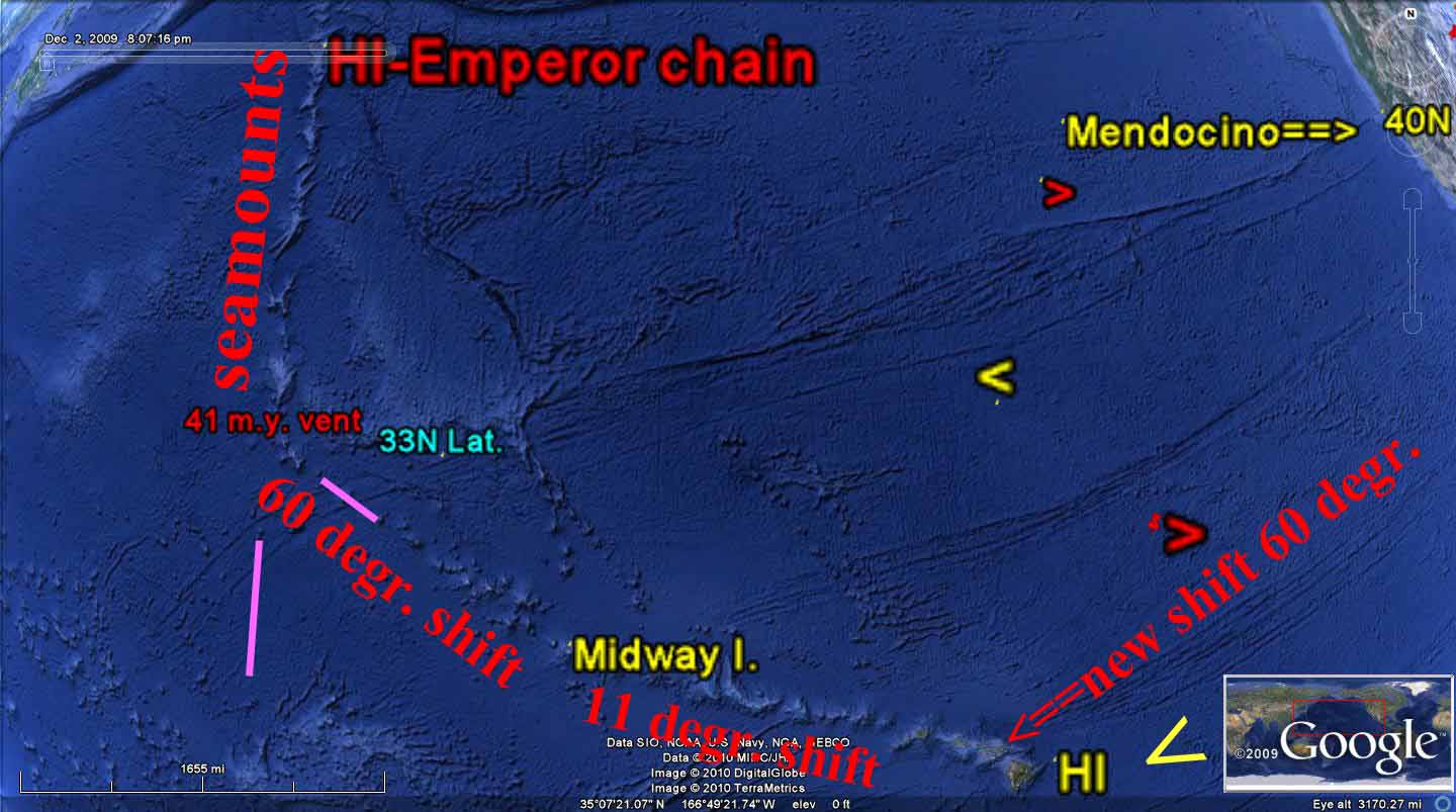 Above is a Google photo of the NW portion of the North American Quadransphere (my term). This presentation, along with other portions, will be used to show that there is a quarter of the globe which moves somewhat independently of the other three (or four) quadrants and oceans. There are portions of the Crust of the earth which protrude above the oceans and react differently to mechanical forces imposed on them, compared to the surrounding oceans and their thinner and more rigid depressions filled with salt water. You will find that the analysis shows entities and movements which are not in the mainstream of features accepted by proponents of the PLATE TECTONICS THEORY, PTT.
 At first, I assumed that there was value to the PTT, and that I could use this as a basis for evaluating what was shown on Google Earth. After 5 YEARS of analysis, I had to discard the parts pertaining to the continental crust, since the lighter and more elevated land masses did not agree with the ideas about “hotspots, mantle plumes, or rectangular plates”. I discarded the theory for explaining events on continents, rationalizing that the theory was developed from ocean observations (MAR spreading and transforming movements on the ocean floors). However, with continued work in ocean basins- where the principal movements seemed to be of a circular geometry, I finally had to abandon using the theory for mechanical movements altogether. Its original discovery of spreading along the Mid-Atlantic rift seems to be of value, and I do not discard that contribution. This feature may be related to a non-mechanical impetus- that of magnetic changes in the Earth’s Core or Mantle- and that is not my field. Hence, I allude to it but try to analyze only the Earth Mechanics’ involvement.
 Above is a Google Earth photo, which shows an important feature FOR understanding the movements of the crust at boundaries of the ocean basins- that of rotation of island arcs throughout time. I name this feature- which has important revelations- the ALEUTIAN SPIRAL. It will reveal several laws of movements of the crust which do not agree with the PLATE TECTONIC THEORY. We will refer to it, using its historic traces and rotations as references for the entire QUADRANSPHERE.


Below is my diagram for one entity which starts the development of movements and activities for crustal masses. This shows how the Mantle drags the Crust, due to its slightly faster spin than the crust- which is slowed by EARTH TIDES and its closer proximity to the moon, than is the Mantle. The diagram is distorted and exaggerated, spatially, but shows the important features of Mantle Drag and Tidal Shove to the west (particularly for the SIERRAS-CENTRAL VALLEY COMBINATION).
 1. THE DIAGRAM, ARRANGED BY ME AS AN ORIGINAL, SHOWS HOW THE FASTER-MOVING MANTLE DRAGS THE CRUST EASTWARD, CREATING SUBDUCTION. THIS IS ONLY ONE OF 4 MECHANICS' ACTIONS, WHICH DETERMINE THE STRUCTURAL ANOMALIES NOTICED IN THE EARTH'S CRUST.
 2. LINEAR MOVEMENTS (THRUSTS) CREATE A DYNAMIC WHICH SIMULTANEOUSLY INVOLVES CORIOLIS, AND WITH WHICH ROTATIONS OF THE CRUST (ENCIRCLING THE LINEAR) ARE INITIATED.
3. EVENTS, correlated with gravitational PERTURBATIONS, DISTORT THESE MOVEMENTS, AND CREATE OTHER WOBBLES AND MOVEMENTS OF THE CRUST. THESE ARE LARGE OR INSIGNIFICANT, ACCORDING TO THE SIZE OF THE IMPACT. THE LARGEST I HAVE STUDIED WAS PTr (PERMIAN-TRIASSIC BOUNDARY at 256 m.y.), THE NEXT WAS KT (CRETACEOUS-TERTIARY BOUNDARY at 64 m.y.) AND OTHERS WHICH ARE SMALLER BUT SIGNIFICANT WHICH OCCURRED AT 41 M.(OE), 28 M.Y.(MIOCENE) AND THE ONE WHICH INITIATED THE ICE AGE AT APPROXIMATELY 2 M.Y.
4. THE 4TH ENTITY IS THAT OF BULGES- SUCH AS THE EQUATORIAL BULGE, EB, WHICH TERMINATES AT MENDOCINO, CA AT 40N LATITUDE (THERE ARE OTHERS, PARTICULARLY THE PEAR-SHAPED ANOMALY IN THE SOUTH PACIFIC- PROBABLY INITIATED BY PTr), AND ANY SIGNIFICANTLY-ELEVATED MOUNTAIN OR DOME). I WILL INCORPORATE THESE ALL- USING FIELD DATA, GOOGLE EARTH, DIGITAL PHOTOGRAPHS, AND EARTH SATELLITE VIEWS OF ATMOSPHERICS AND OCEAN MOVEMENTS (WHICH ARE DETERMINED BY MOON-CREATED TIDES, OR EARTH TIDES).
5. THE FIFTH CATEGORY IS ONE WHICH WILL INTERRRUPT THIS ANALYSIS LATER IN THE PRESENTATION. IT IS THAT OF THE VARIOUS ORBITAL ROTATIONS, TILTINGS, ELLIPTICAL VARIATIONS, AND PERTURBATIONS OF THE EARTH IN ITS REVOLUTION ABOUT THE SUN. MILANKOVITCH CALCULATED THAT THREE OF THESE HAVE NOTICEABLE AND CONFIRMED INFLUENCE ON EARTH'S CLIMATE; THESE ARE THE PRECESSIONAL (25 k.y.), AXIAL (TILT OF 41 k.y.), AND ELLIPTICAL (DEVIATION FROM CIRCULAR, DUE TO INFLUENCE OF SATURN, URANUS, AND NEPTUNE'S GRAVITATIONAL PULL) OF 100 k.y. CYCLES. THE ROCKS AND OUTCROPS OF MOUNDS IN MY AREA OF FIELD INVESTIGATION SHOW CIRCULAR PATTERNS OF OTHERS. THESE SO FAR INCLUDE ONE MILLION DOWN TO 15,625 YEAR CYCLES, AND I EXPECT THAT I WILL FIND MORE THAT MILANKOVITCH HAD INSUFFICENT TIME TO INCORPORATE (WORLD WAR I ENDED, WITHOUT GIVING HIM ADDITIONAL INCENTIVE TO INVESTIGATE FURTHER). These are shown in a MODEL for those seen in the ATMOSPHERE, as an ANALEMMA, and they are initiated by the OFFSETTING REACTION of LUNAR vs. SOLAR TIDES:

 Notice that the PROPELLOR-SHAPED LUNAR vs. SOLAR CONFIGURATION occurs at the SW (west of the great MUSHROOM-SHAPED ARC). This is best-presented during the full moon, with high pressure and clear skies. This is in the SOUTHERN HEMISPHERE, where all is reversed, and the propellor blades are reverse to my DIAGRAM.
THE QUADRANSPHERE (MY WORD!) IS AN ELLIPSE WITH GAPS. THE TWO MOST IMPORTANT ARE IN THE EASTERN PACIFIC, SOUTH OF HAWAII AND THAT BETWEEN THE PUERTO RICO TRENCH AND THE MAR (MID-ATLANTIC RIDGE):
BELOW IS A MODEL FOR THE CORE-MANTLE INTERFACE, WHERE THE CORE IS HYPOTHESIZED TO ROTATE FASTER THAN THE MANTLE. I DON'T USE THIS MODEL, SINCE I FIND THAT ALL STRUCTURAL CHANGES INVESTIGATED ARE THE RESULT OF CRUSTAL MOVEMENTS (VERSUS THE SLIGHTLY FASTER-MOVING MANTLE). THE GAP SHOWN IN THE ATLANTIC NE OF THE PUERTO RICO TRENCH IS SHOWN, BUT THE GAP SE OF HAWAII IS NOT SHOWN. THIS IS AN IMPORTANT DIFFERENCE, SINCE I FIND NO CRUSTAL ANOMALIES IN THAT REGION. THE NORTH AMERICAN QUADRANSPHERE, Qsna, IS AN ELLIPSE (AS IS SHOWN IN THE MATSUSHIMA-PINE ISLAND) MODEL, BUT IT SO FAR SEEMS TO BE MOTIVATED BY GRAVITATIONAL EVENTS AND WITH CORIOLIS ROTATIONS OF THE CRUST (WHICH ARE INITIATED BY POLAR WOBBLES AND EARTH TIDES):
NOTE: THE FOLLOWING REPORT AND ANALYSIS IS AN ON-GOING INVESTIGATION. YOU WILL FIND MINOR ERRORS (AND SOME MAJOR ONES, since I initially believed that there was some VALUE to the PLATE TECTONIC THEORY; I NOW FIND THAT THE ONLY USEFUL PART OF THE PTT IS THAT AT THE MAR, WHICH SHOWS THE MAGNETIC STRIPING AS A RESULT OF EXTENSION AND LATERAL MOVEMENT ALONG THE RIDGE). THE ERRORS ARE GRADUALLY BEING CORRECTED AS I PROCESS MORE CASES PERTAINING TO THE CIRCUIT MADE BY THE ROTATING QUADRANSPHERE. FOR EXAMPLE, IT NOW APPEARS THAT THE REASON THAT ICELAND REMAINS RELATIVELY STATIONARY THROUGHOUT TIME IS THAT THE KT STRIKE HAS BEEN OFFSET BY AN EVENT OCCURING APPROXIMATELY 34 TO 41 M.Y. AGO. THIS IS SIGNIFICANT, AND I AM LOOKING AT OTHER FEATURES WHICH BEAR ON THIS MAJOR DEVELOPMENT. CONTINUE!


THE NORTH AMERICAN QUADRANSPHERE, Qsna, IS TRACED BY A PARTIAL ELLIPSE, FROM CENTRAL AMERICA TO THE PUERTO RICO TRENCH (THEN A GAP TO THE MID-ATLANTIC RIDGE), TO THE ARCTIC OCEAN (SHIFT AT GAKKEL RIDGE TO LOMONOTOV), AND THROUGH SIBERIA TO THE HAWAIIAN-EMPEROR SEAMOUNT CHAIN, TO THE BIG ISLAND OF HAWAII (LOIHI IS THE YOUNGEST FEATURE INVESTIGATED). THERE IS NO INFORMATION FOR THE DEEP NORTH PACIFIC OCEAN SOUTH OF HAWAII (THERE IS A GAP THERE, AS WITH THE CASE FOR THAT OCCURRING NE OF THE PUERTO RICO TRENCH, AND WE WILL START WITH CENTRAL AMERICA, WHERE A RIFT HAS DEVELOPED OFFSHORE.FURTHER INFORMATION:

Summary: THE INITIATION IS SHOWN BELOW, IN A GOOGLE PHOTO OF THE REGION, WHERE CENTRAL AMERICA HOLDS THE CLUES TO THIS "EARTH-SHAKING EVENT".
 PHOTO ABOVE IS AN EXPANDED VIEW OF THE BELOW GOOGLE PHOTO OF THE BAJA PENINSULA. THIS CONTRAST SHOWS THE ROTATION ON LARGE AND SMALL SCALES- OF THE OFFSHORE SEDIMENTS- AS THEY ARE STRAINED BY GRAVITATIONAL EVENTS.
GPS HAS MEASURED THE MOVEMENTS, REPRESENTED BY VECTORS, OF VARIOUS LOCATIONS ON THE EARTH'S SURFACE. THESE ARE SHOWN BELOW, TO CHECK MY WORK ON ANALYSES MADE USING CIRCULAR RIVER PATHS, SLICKENSIDES' STRIATIONS AND "CAT STEPS" DIRECTIONAL INDICATIONS, SHEAR OF CONCRETE SLABS, AND SHIFT OF RIVER MEANDERS AND OSCILLATIONS ACROSS RIVERS:

Notes for the GPS movement vectors shown above:
1. GPS IS MEASURED WITH CRUSTAL VECTORS REFERENCED TO EARTH, where land mass moves NW as seen AT HILO, HI. WHEN A VECTOR IS TO THE SW, THE CRUST MOVES SW RELATIVE TO THE NORTH POLE. At the Aleutian Islands, it is moving South, and this introduces the first problem to those who believe in a northward shove of the Emperor seamounts with time. The GPS measurements cast doubt on the assertion that there are "hotspots", plate movements to the north, and MANTLE PLUMES, CREATING THE ISLANDS.

BY MY APPRAISAL, HI IS MOVING ALONG THE KONA COAST CW (SINKING), OPPOSITELY TO THAT ON THE EASTERN SIDE OF THE ISLAND WHERE THERE IS STILL ACTIVE RISE, CCW, OF MAGMA. THE WEST SIDE IS SHRINKING AND COOLING. THE ISLAND'S EAST SIDE IS MOVING DIFFERENTLY THAN THE WEST SIDE; IN OTHER WORDS, ROTATION IS CW AT KONA, AND CCW AT HILO.


THE KILAUEA CIRCULAR ROTATION IS SHOWN, UNINFLUENCED BY MY ANALYSES, ABOVE.
2. After exiting EB, north of the transform crossing the 41 m.y. kink in the HI-Emperor seamount chain, the Pacific track is N-S, as shown by the track south of the Aleutian Islands.


Canyon de Shelly, NM is another example of ORTHOGONAL SHEAR, FORMING CANYONS:
 And the Zambezi falls in AFRICA:
.jpg)
 BELOW IS A SERIES OF PHOTOS FROM GOOGLE EARTH, WHICH SHOW THE PROGRESSION OF THE ISLAND TREND AS THE SOLAR TIDE OFFSETTING LUNAR TIDE CREATES AN ORTHOGONAL CANYON- CAUSING EXTRUSION OF BASALT AT THE INTERSECTION (LOOK for the ORTHOGONAL LINES to the SE of the "BIG ISLAND"). THIS IS SIMILAR TO THE NIAGARA WATERFALL- WITH SCARPS AT RIGHT ANGLES TO EACH OTHER (in the NE corner of a block of earth crust, showing ORTHOGONAL SHEAR FEATURES):


CONTINUING WITH THE ROTATION OF Qsna (these photos were analyzed 3 years ago, so that the latest assessment is not shown):
It appears that the KT strike movements may have been later offset by the 41 m.y. POLE SHIFT movements of late Eocene age, so that ICELAND APPEARS TO REMAIN RELATIVELY FIXED IN EARTH SPACE:

I can now see that the earth’s response is to display DISRUPTIONS TO ITS BEHAVIOR via three independent forces, creating the dynamics of the Crust:
A. The slowing of EARTH'S ORBIT (which elongates its path around the sun) is an EXTENSIONAL PROCESS- where earth expands, opens grabens, and increases the diameter, due to the tidal friction between earth, SUN, and moon, causing slowing of the spin rate of the earth and length of day increase, LOD. This factor due to the sun, creates a lengthening of the day by 24 seconds each million years, or 6 nautical miles (6 minutes of arc) and shear to the East along latitude lines between 40N and 40S latitudes. Moon has an opposite influence- that of COMPRESSION, whenever the NEW MOON pulls earth TOWARDS SUN. (NOTE: I HAVE SUBSEQUENTLY FOUND BY MEASUREMENTS ON GOOGLE EARTH, THAT THE SHEAR IS LARGER in ISOLATED NORTHWEST QUADRANTS of BLOCKS of CRUST- 20 km EACH m.y. COMPARED TO THIS LONG TERM MOVEMENT OF ABOUT 10-11 km/m.y.) The EQUATORIAL BULGE, EB, LATITUDES GREATER THAN 40N MOVE EASTWARD RELATIVE TO THOSE INSIDE THE BULGE. THIS MAKES IT APPEAR THAT THE ZONE INSIDE EB (northern hemisphere) MOVES WESTWARD WITH TIME;
B. Coriolis Rotation is created by the difference in surface spin velocity along latitude lines (velocity at the edge of a parcel of mass is less as distance from the Equator is increased). Notice the CCW rotation for Mt. St. Helens, below, creating a circular presentation of a minor stream- which displaces the major stream to the west by the rotation;

and,
C. Meteor Strikes- mechanical shocks, which create shear in the Crust along the direction of impact.

Examples for A. include the SHIFT OF A BULGE WESTWARDS (SIERRA MOUNTAINS, CA) BETWEEN THE 41 M.Y. TRANSFORM AT MENDOCINO TO THE GARLOCK FAULT (which traces E-W), visible until the HI-E SEAMOUNT CHAIN IS REACHED. THIS IS A SEGMENT OF THE CRUST WHICH IS MOVING WESTWARD, OPPOSITE TO THAT SURROUNDING IT (THE CASCADE VOLCANIC BELT TO THE NORTH AND THE DEATH VALLEY AND GEOTHERMAL REGION BELOW TO THE SOUTH AND EAST). NOTE THAT THE PHOTO HAS BEEN ROTATED 45 DEGREES, SO THAT THE MAXIMUM BREADTH MAY BE VIEWED:

Examples of B. include the rotation of cells within cells of protruding land mass, as Coriolis force affects the taller of mountains versus the lower elevations, and the north side of any feature versus the south side (the side where the Earth surface velocity vector is greater, referenced to space. REFER TO THE GOOGLE PHOTO OF THE E-W TRENDING UINTA MOUNTAINS, BELOW, TO SEE HOW ROTATIONS OCCUR AT THE INTERSECTION OF THE EQUATORIAL BULGE (LESS THAN 40N LATITUDE) AND THE CORIOLIS ROTATION OF THE MOUNTAINS TO CREATE THE GREEN RIVER CUT THROUGH THE RISE TO PRODUCE THE FLAMING GORGE:

My analyzed version of the Uinta Mountains is shown below:

Examples of C. include the obvious inflection of the Hawaiian-Emperor chain at the 41 m.y. age as it was deviated by the RISE OF THE SIERRAS, and subsequent tidal shove of the mountain bulge westward (SEE THE FIRST PHOTO SHOWN IN THIS BLOG ABOVE), and the portrait of Equatorial transforms in the Atlantic basin as they shear 300 miles or so (westward on the north side of the Equator) after the KT strike near Yucatan, Mexico:
The NA Quadransphere is the simplest of the four crustal blocks, all moving under different impetus: Australia by the PTr event, Africa by the great rift, North America by the KT strike off Yucatan, and South America by the combination of Mantle drag and the Andes moving westward. Coriolis rotation, is initiated by any independent movement- such as shear at EB, EARTH-instability events, and expansion by heat from radioactivity or solar input.


the N-S SHEAR LINES are an important factor in the development of LUNAR-SOLAR OFFSET in CRUSTAL DIVISIONS. The sun in the NE, SE and at margins of SE-SW and SW-NW QUADRANTS exemplify that shear and THRUSTING, CANYON INITIATION, and VOLCANO EXXTRUSION OCCUR there!
 This is exemplified at the NW PASSAGE and at the MAR:


Iceland is the location where there is divergence of the NA and Europe Quadranspheres:
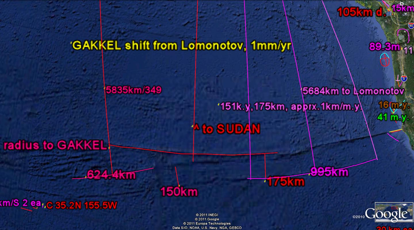 The earth has endured several destructive episodes, as shown in the FOSSIL RECORD. The 64 m.y. KT and 256 m.y. PTr die-offs have been well reported by geologists, but the 41 m.y. EVENT has hardly been noticed. It is shown in the Kimmei Seamount in the North Pacific, and I have discovered it in the separation of the Lomonotov and Gakkel ridges, in the AGE of the Central American curlicue, and the shove of Eocene sedimentary rocks onto the Olympic Peninsula (m Mountains), WA. This feature is important in the DYNAMICS of the EARTH, since in all the cases listed above there was (and still exists) GEOTHERMAL ACTIVITY and major movements of the CRUST. Notice that: 40 m.y. x 1.6= 64 m.y. or alternatively 40.96 m.y. x 1.6= 65.5 m.y, the age of KT as measured by radioactivity dating. The first of these is from the BINARY THEOREM, where the series runs: 2, 4, 8, 16, 32, 64, 128, and 256m.y. etc. this series indicates that with less than 4% error, there are destructive events at multiples of 4 (4, 16, 32, 64, 256, etc to 1024 m.y.- the AGE of the GREAT UNCONFORMITY, noticed in the Grand Canyon, as a missing layer of crust of at least a half billion years of deposition); other 4x multiples, such as 2048, and 4096 million- the age of initiation of the GRAVITATIONAL INFLUENCE of the MOON, exhibit drastic ANOMALIES! I HAVE ENDEAVORED to find which (40 or 40.96) is formulated by the GRAVITATIONAL INFLUENCE of the solar system, and I have measured both in OUTCROP SHEAR CIRCLES. Hence I have left it to future work to find the correct magnitude, while realizing that there is only 2.4% difference between the two numbers. This introduction is illustrated by the occurrence of the 41 m.y. separation, of a 3.6 degree/360 circumference (40.96 m.y.) between the GAKKEL and Lomonotov RIDGES, and that this represents the change of the EQUINOXIAL ANGLE- as shown by the RATIO of 41m.y. (40.96?)/4.096 b.y.= 1/100. this indicates that an EVENT OCCURS each 41 m.y. to move the POLES, simultaneous with a shift of the EQUINOXIAL ANGLE (TROPIC of CANCER). There is now an association of three events: 41 m.y. shift of ridges, extrusion of Kimmei seamount, and the Central America, and the shift of the POLAR PRECESSIONAL ANGLE. This is all shown on the Google Earth Arctic presentation:
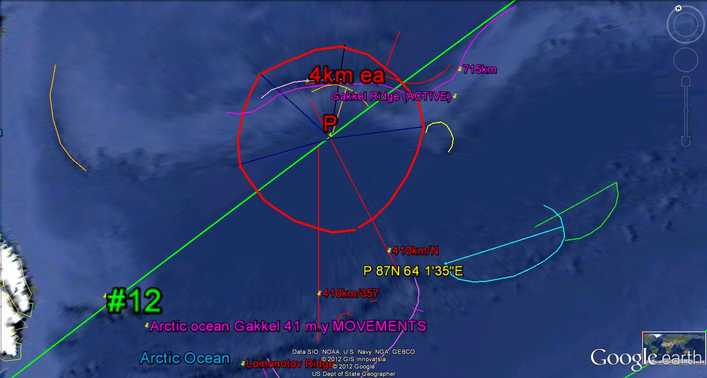
This has ASSOCIATED EVENTS in the 41 m.y. cycle of the BASIN and RANGE, B&R- Colarado Plateau, CP movements. The B&R lags CP, and is now active, since the 41 m.y. RISE of the Sierras. The activity is noticed at Mammoth Hot springs and Yellowstone GEOTHERMALAREA, where bothe regions are OPENING, ALLOWING EXTRUSIONS and violent movements;

1. Find a PC outcrop of AGE 1.024 B.Y. OR MORE, to determine whether there are more that have "escaped" the great UNCONFORMITY (SCALPING) found in the GRAND CANYON in a GRABEN. I hope to shed more light on the "EJECTION" of half b.y. or at least 960/pi= 305.6 km of missing stratigraphic column (except for elliptical waves found from AZ to Canada), and
2. Determine whether the Snake Range has expanded, starting in the POST-mesozoic, at about the 41 m.y. AGE:
 GOLD was Above ANOMALY is found to the west of present Great Basin NP, in the Osceola area to the NW. This area has a good gravel road, where MIMA MOUNDS and analemma ANOMALIES may be seen:


There occur 2 of these FEATURES along the path of the Colorado River, in the Grand Canyon; the westernmost is the smallest- indicating that it is the youngest. Using this clue, we can finally find the APPROPRIATE ANALEMMA, so that the GRAND CANYON PROGRESSION may be solved!

Although this ANALEMMA LOOKS CORRECT, it is NOT! The RATIO of the 2 features is not 1.6- which I find to be INVARIABLY EXHIBITED, when the proper analysis is made!
Analyzing a LARGER FEATURE, we find that the KEENEST CLUE is that for the LARGEST or oldest ARC, this is near 14 m.y.- which is the Basin and Range OLDEST EXTRUSION and fartherest west RHYOLITIC INTRUSION at the ID, NV, and OR border. At that time, the SIERRAS WEST SHOVE created EXTENSION-OPENINGS in the previously WEST-MOVING TIDES, and initiated EAST-MOVING EXTENSIONAL BASINS. The oldest occur immediately east of the Sierras, and the ones most recent near the GREAT BASIN NP, or Mt. Wheeler:

Above GOOGLE EARTH PHOTO exhibits the 2 parts of the 14 m.y. ANALEMMA, and the RATIO 1.6 is shown- as ACCURATELY as I can calculate (remembering that my normal errors are less than 5%). Notice that there is also a TRANSITION ZONE- which is always the case, for the zone between the 2 OPPOSITELY-ROTATING ENTITIES (AXIAL CCW- PRECESSIONAL CW). As I have found in all cases, there is an OLDER-WIDER DIAMETER- that of the Mogollon Rim, and it in turn is part of a YET-LARGER ONE, until reaching the EARTH LIMITS (40,000 km/pi DIAMETER, or 4096 m.y. LUNAR GRAVITATIONAL INITIATION)


 We will return to the LARGER VIEW of Qsna, at the North Pole- Gakkel ridge EQUIVALENT TO THE B&R at 41m.y. changes of the EQUINOX:

 NOTE: AN INLAND LAKE, COVERED BY ICE, OCCURS INSIDE THE ISLAND OF GREENLAND. THIS MEANS THAT A DEPRESSION OR SINK HAS CREATED CW ROTATION OF THAT PART OF GREENLAND (FOUND BY GEOPHYSICAL MEASUREMENTS).
ANALYSES OF CIRCULAR PATTERNS AND RIFTS SHOWN NEAR AND AROUND THE ISLAND OF ICELAND:


The Fourth Quintile
The fires of life are burning low
The selvage width is thin;
The distant view of long ago,
Of things concerning men,
Is waning as the coast seen far,
Like dimming fog seems now.
But deep within the earthen jar
Remains a Willful vow.
That Spirit assailed so soon by Time-
Which took so long to form-
Is waxing yet o’er all so prime
(Much like the distant storm).
Physique may gracefully fade away
And quick of wit may slow,
But Emotion remains strong to this day
Beneath the Psyche’s glow.
Harold L. Overton
BELOW, THE VIRGIN RIVER AND SAND MT. UT FEATURE IS PRESENTED IN A DIAGRAM, SO THAT YOU CAN SEE THE IMPORTANT FEATURES, for an area exhibiting an ANALEMMA where LINEAR-THRUSTING and RISE vs. SINKING occurs:

The ORIGINAL was discovered for the Aleutian SPIRAL- which is a FEATURE OCCURRING from approximately 80m.y. (80.92?) to the TERTIARY. This represents a TIME INTERVAL, NOT an AGE! I have subsequently found that there is a repitition of the COMPLETE CYCLE each 41 m.y., and I will attempt to find the COMPLETED CYCLE of 41 to 82 m.y. somewhere in the EARTH'S CRUST. The Colorado Plateau is the latest, and I suspect that the plateau north of the HIMALAYA UPLIFT is the one. STAY TUNED!
 The Tibetan Plateau is shown below, to initiate the search for the PREVIOUS 41 m.y. CYCLE. Notice that the ORTHOGONAL DIAMETERS of the ELLIPSE are 2:1 in RATIO. It appears that an ELLIPSE requires twice as much time to form, as do the circular features internally!

A "WONDER" I visited while assisting UNESCO was the TRAVERTINE DEPOSITS of PAMUKKALE (cotton castle). TURKEY:


Although ANATOLIA has exhibited TWO 41 m.y. CYCLES, it requires excessive analysis and added field work to decipher the EARTH WAVES! Two of these are shown, but it will be remarked that this is EXTREMELY SUBJECTIVE. Hence I will return to those close to my area of HIKING- e.g. the PARIA PLATEAU- which can be easily accessed. This is not a 41 m.y. feature, but exhibits a SMALLER-in-time RESONANCE:

PARIA PLATEAU and the VERMILLION CLIFFS:
The Paria Plateau is an uplift remnant, since it stratigraphically correlates with the surrounding terrain. It remains because of its extra compaction due to its rotation (“twist”) of the feature within an isolated block of the CRUST OF THE EARTH. It is roughly in the shape of a trapezoid, which I have found has dimensions such that their ratio is 1.6 (see accompanying photo). The largest ANALEMMA (a figure 8) almost fills the trapezoid, with two arcuate features of RATIO 1.6. There are other smaller and younger analemmas than the largest one, and they all have the ratio of RISE/SINK DIMENSIONS of 1.6, when measuring at their widest diameter The Vermillion cliffs occur on the south side of the Plateau, and yield a rebuttal to unusual compaction, since they appear to be crumbly- not compacted, but this does not pertain to the interior- which is being sheared, rotated, and compacted. When one examines the edges, the immediate conclusion is that they are arranged in arcuate patterns: Milankovitch cells or cycles adjoining each other in an E-W ORIENTATION. The plateau is expanding with time- 10.24mm/year outwardly- in the NW corners (30.72 in the SW corner), creating thrust faulting locations at the INTERSECTION, with the stratigraphic bedding tilted upwardly to the exterior of the feature. This would be called “rollover” by oil geologists, and is caused by the outward expansion of the plateau- particularly at corners where the stress of the shove is accentuated. WHY ALL THIS ATTENTION TO ANALEMMAS? These result from the DOMINATING INFLUENCE of the GRAVITATIONAL LATERAL MOVEMENTS created by the EARTH-MOON-SUN COMBINATION! I suspect that the entire solar system exhibits a similar result, particularly VENUS- since its ORBIT RATIO to EARTH'S is 1.62. Incidentally, the EARTH is a subdued ANALEMMA, but difficult to see because of EROSION, with the PEAR-SHAPED SOUTH PACIFIC exhibiting rising VOLCANIC ISLANDS. As well as I can measure on GOGLE EARTH, the extra diameter bulging is only about 4 km out of 40,008 km circumference (+.001%).
Expansion outwardly with TIME of movement is due to the continual action of GRAVITATION- the attraction of the EARTH by the combined mass of the Sun, Moon, and Planets. The main culprit is the sun, and it has a constant effect of attracting the earth by 10.24mm/year- FRICTION. This happens because of the fairly constant separation of the earth from its STAR. This is not precise, since the earth is being moved outwardly in an elliptical configuration by the gravitational influence of other bodies in the solar system- planets mainly, but with large bodies such as asteroids (Ceres, the largest) also. I have found that are at least 10 orders of mass or size, which affect outcrops down to the smallest you can examine with your eye. Consequently you will measure larger movements than 10mm/yr, particularly when the arcuate patterns are convex to the west. Solar-generated movement arcs are convex to the east, and create the smaller movements- particularly when there is an offset of the westward movements to create canyons. SHOULD YOU WANT TO SEE THIS EFFECT, CONSULT YOUR WATER TIDE TABLES! The smallest NET MOVEMENTS are near zero, particularly for the ICE AGE, where I have found 1 mm/year for Whidbey and Orcas Islands- near the last westward movement of the glaciers, at Penn Cove. and San Juan Islands.
The next largest influence of mass and gravitation is the MOON. It is largest and closest in effect, because of its proximity, and it causes the EARTH to oscillate about the center of mass- the barycenter. This is about 1710 km below the surface of the earth, and is the point about which the earth and moon rotate around the circle WITHIN the ECLIPTIC PLANE of the yearly travel of the BINARY COUPLE of EARTH-MOON. The ratio of the radius of the barycenter to the radius of the earth Re/Rb is 6350/4640= 1.37, and this is significantly smaller than 1.6 = the normal ratio of RISE/SINK for features such as the Colorado Plateau/Basin & Range. The yearly oscillation of the EARTH-MOON ALONG the Circular or ELLIPTICAL PATH creates a “sloshing” or gyration of water in creeks from one bank to the other, and this creates MEANDER-LIKE paths. The creation of ALLUVIAL FANS is anther result of this periodic gyration of the earth (WOBBLE of the POLES), and this occurs in a roughly 25,000 year period. The movement from side-to-side is a gradual and continuous one, so that the erosion and deposition of sediments in a fan (or meander) is smooth. The possible exception to this is the time of reversal of the TILT of the POLES (CALLED THE ANGLE OF THE EQUINOX- currently about 23.5 degrees). This reversal creates a discontinuity or inflection in the shear pattern noticed in outcrops.

Altogether: CHATTER= 1m ({T- 1000 years} x f(TIME)[cosine s-1]) x sine (RATE x sine T), and the constant 1- initial RISE in meters- must be inspected with case histories, as must the limits of T- which is probably cyclically-related (since this relation depends upon the size of the BLOCK investigated). There are at least 10 year, 100 year, 1000 year (1 k.y.), 10 k.y., 100 k.y.- Milankovitch's elliptical cycle, 1 m.y., 100 m.y. and b.y. cycles (which accounts for the 1.024 b.y. GREAT UNCONFORMITY found in the Grand Canyon- where at least a km of the stratigraphic column was "SHAVED OFF").
The chatter constant should be confined to a 10:1 variation, since it belongs to a PARTICULAR BLOCK; this constricts T to a 9x maximum variation, so that CHATTER VARIES from 1 to 9 meters in the smallest block, up to 1000 to 9000 meters (9 km.) in the million year block. The maximum elevation possible is for the b.y. time interval: 1000 k.m.- which is for METAMORPHIC ROCKS, and is offset by EROSION in the last term of the equation:
The maximum variation of CHATTER is that for the Himalayas- 8000 meters, 10 km for the Marianas TRENCH.
CHATTER= ( 1m to 1 km, varying with the cycle)({T- 1000 years} x f(time)[cosine s-1]) x sine (RATE x sine T), where the VARIABLES: CYCLE, RATE, and TIME must be INDEPENDENTLY DETERMINED!
DIVIDE COMPARISONS for Hf and PARIA PLATEAU:
The finding that there was a canyon and the PARIA DRAGON RISE at the maximum elevation of the House Rock Valley road- oriented E-W from each other- is significant. This indicates that there is gravitational influence at these rises, or uplifts: CONFLICT BETWEEN 20 LUNAR- 10 SOLAR. This was also observed at the Hurricane fault, near the southern border of the Sand Mountain uplift. There the maximum elevation (called the Divide) occurred between two volcanic intrusions (also called Divide Volcanoes). Between the two there was a spillover of basalt over Hf, directly in line with the two basalt craters. The dated flows should make an interesting comparison, to find the commonality:
geological PROPERTY COMMENTS: Correlations, Longitude, orientation
CATEGORY N-S Faults or Monocline boundary; Mz-Pz contact
Hf fault: valley in a saddle at 113 18”W; Mz to west; 1m.y. AGE;
Basalt has moved 2.6 km west (2.6 mm/yr); movement is LUNAR DOMINATED (reduced by solar offset)!
Paria: similar; Mz to east: 112 3’W- 113km/102 east separation;
NO Vulcanism, Canyon west and rotated uplift east; 1.5m.y ellipse Pk RISE centered about smaller ellipse at 36 50’54N 112 5’50W DRAINAGE DIVIDE (top of rise?); VALLEY is 1.12km wide, or 56k.y. expansion, with 48k.y. drainage arcs (14% diff.); Kaibab is moving eastward faster than PARIA westward, resulting in narrowing of valley at the highest elevation (24.5mm/year NET SE movement-analemma developing on Paria plateau). SOLAR DOMINATED, but likely 20.48mm/yr, due to measurements errors!

CHICXULUB EVENT shows the relation of GRAVITATIONAL WAVES to unusual events, such as the Clintonville, (WI) BANGS:
Below photo of the Yucatan Coast and bordering Gulf of Mexico exhibits the region of the 64 m.y. (65, by radio-dating) dinosaur extinction event. This event has been categorized by Dr. Alveraz and son as a Iridium-related site of an ASTEROID, dubbed the Chicxulub strike. It is named after a locality in Mexico, where a layer of Iridium was found at a shale measured by radioactivity. This site, which has been called an asteroid crater, is more likely the site of a DISCONTINUITY in the GRAVITATIONAL WAVES determining MOVEMENTS in the SOLAR SYSTEM* (the asteroid may have been a "TRIGGER", ACCELERATING EVENTS) in the rotation of the North American continent- an inflection in the rotation of the land mass according to the series 256, 64, 16, 4, 1 million years. The more general BINARY THEOREM series are abrupt indentations in the TIMES of 2, 4, 8, 16, 32, 64, 128, 256 m.y., on to 4096 m.y. or 4.096 billion years- the AGE of the GRAVITATIONAL ATTRACTION of the MOON (before which there was no lunar tides, either land or water). I have found that, not only were there extinctions in the 4x series, but that there were drastic events at each inflection: PTr event at 256m.y. at Cape Hatteras, Columbia flood basalts changes at 16m.y., creation of the NW passage at 4m.y. (Byam Martin Island), and rejuvenation of the rotation on the east coast at 1m.y.
*GRAVITATIONAL WAVES exhibited by Google Earth and the BINARY THEOREM:
The record, as I interpret it, is that of gravitational waves (traveling at the speed of light) “working” outwardly from the SUN, and becoming lesser in effect with TIME and DISTANCE. We see that there were the most drastic events occurring early and these become of less importance with time; e.g. the best documented was that of 256 m.y. PTr- where 90% or so of living objects (shown by fossil count) became extinct. The next discontinuity or instability resulted in the disappearance of DINOSAURS at the 64 m.y. AGE. This was not quite as severe, with more than half of life becoming extinct. Next in the progression of time was the 16 m.y. FLOOD BASALTS of NW USA, where a region was affected, but less obvious in the fossil record. Then there was the BREAK-UP of the landmass to the NW of Hudson Bay, centered at Byam Martin Island at 4 m.y. (as measured by the diameter of the island, since time interval is proportional to arcuate diameter).
It is easy to see in SPATIAL DISTANCE the “FORBIDDEN ZONES”, where planets do not survive in the asteroid, Kuiper, and Oort belts. More difficult to visualize is the progression of TIME on the surface of the EARTH. The FORBIDDEN ZONES on earth are the catastrophes occurring at 256, 64, 16, and 4 m.y., where climate, weather, evaporation, rotation of regions, and shear of outcrops occur in patterns of BLOCKS of CRUST, as with the PARIA PLATEAU shown above. Further, a reduction of SEVERITY of events occurs as TIME PROCEEDS. I have hints that the sequence continues at 1 m.y., for the next zone- that at Cape Hatteras (continuing the CW rotation around the NA Continent with intermittent “jerks”). I further observe this entity in small outcrops, where there occur linear separations in rocks and features at a linear DIVISOR. This occurs at the Hurricane Fault, which represents a continuation of the WASATCH LINE. This line represents a discontinuity in the STRATIGRAPHIC RECORD, as well as in the break in time.
The most fortunate aspect of the GRAVITATIONAL WAVE DISCONTINUITIES is the diminution of severity with time, where the “DIE-OFF” becomes smaller with time.
Now we see that Chicxulub is at the same longitude as the “BANGS” at Clintonville, WI. There are several possibilities for this anomaly in sounds:1. Two creeks junction at the town, and this creates a rise or geological anomaly at the junction. Not only is there a temperature rise, due to the friction of shearing below the creeks, but there is an uplift, according to the MILANKOVITCH cycles of 25 and 41 k.y.;
2. The N-S line connecting Chicxulub and the 40m.y. Hudson Bay is 4096 km in length. This denotes that another event has arisen to move the line of shear toward Byam Martin Island, and this event is inflected by the 41 m.y. anomaly. This creates an ellipse for the NA continent with an E-W diameter of 4096 km, and a N-S (diverted to the NW) diameter of (1m.y. or 20.48km and 40 m.y. or 819.2km to the NW). This totals 839.68km, which added to the 4096km is the distance from the 41m.y. sediments of the Gulf of Mexico to the edge of the ELLIPSE of the NW passage; and,
3. The continent is expanding into an ELLIPSE- moving 10.24mm/year to the west from Mendocino, CA, and enlarging 6553.6km (1.6x) from Chicxulub to the north side of the NW Passage ELLIPSE. I may have an error, by using 1.6, rather than 1.62, as shown by the RATIO of orbit times for EARTH/VENUS.

Transform Regularity in the Pacific basin:
The Google photo below shows that there is a geometric arrangement to the parallel transforms in the North Pacific Ocean:
The transforms of most interest are those at the Kimmei seamount and at Midway Island. Continuing southward, the spacing is 7.2 degrees of Latitude, at the North and part of the SouthAmerican coast for the major parallel transforms, on into South Latitudes. This suggests that whatever initiates the transforms is released in the form of shear along the transform at regular GEOMETRIC intervals. This hints that the inflections created by this process along the HI-Emperor chain is partly determined by geometry.
NOTICE THAT THE SIZE OF THE CIRCULAR PRESENTATION IS LARGEST AT THE NORTH (Kimmei), and decreases regularly to the south- SHOWING NO CIRCULAR FEATURE WITH THE ISLAND OF MAUI (THE LATEST INFLECTION LOCATION). Incidentally, the 7.2 degree latitude spacing is not replicated for the other oceans; the Atlantic Ocean has some regularity (at about 3 degree latitude spacing). Other oceans are under different impulses: the Indian Ocean is influenced by the antipode to Kt; the Arctic by polar shifts, and the SW Pacific by the northward Australian movement.
In summation, it appears that we still have two factors influencing the orientation and appearance of Pacific Ocean transforms:
1. THE ANOMALIES SHOWN AT KEMMEI SEAMOUNT (AND OLYMPIA PENINSULA, ROTATION OF THE COLORADO PLATEAU, AND SHIFT WESTWARD OF THE SIERRAS- ALL STARTING ABOUT 41 M.Y. AGO) AND AT THE NORTHERN-MOST SEAMOUNT AT 65 M.Y., ALONG WITH THE POLAR SHIFT, ALEUTIAN SPIRAL, AND FORMATION OF THE ROCKY MOUNTAINS ARE RELATED. THE MIDWAY INFLECTION AT 28 M.Y. INFLUENCES THE ORIENTATION OF TRANSFORMS AND THEIR MOVEMENT AONG THE HAWAIIAN CHAIN. HOW TO CONFIRM ALL OF THIS WITH FIELD OBSERVATIONS? ONE METHOD IS TO MEASURE SLICKENSIDES STRIATIONS' ORiENTATIONS AND THEIR DIRECTION OF MOVEMENT ALONG FACES ON OUTCROPPING ROCKS. I HAVE FOUND THESE IN IMPORTANT PLACES- CHIEF OF WHICH ARE THOSE AT MENDOCINO, CA. Below are shown how slickensides are initiated along sheared and uplifted areas on Whidbey Island, with a view of understanding how this mechanism proceeds:

BELOW IS THE THRUST, LATERALLY, OF INTERGLACIAL SILT, TILL, AND SEDIMENTS WHICH FORM THE INITIAL PRE-STONE CONTAINING THE EARLY SLICKENSIDES COMPRESSIONAL THRUST. NOTICE THAT THERE IS A DARK CHERT-LIKE (but NOT AS HARD) INTERIOR AND A SOFT SILT COVERING. THESE SLICKS ARE USUALLY SHAPED LIKE AN OVAL LATH, TAPERING TO AN EDGE ON ALL SIDES, AND ARE SOFT (BREAKABLE WITH THE HAND) QUATERNARY NODULES. THE PHOTO BELOW SHOWS THAT THEY FORM AT THE HIGH-STRESS LOCATIONS OF LATERALLY-MOVING SHEAR PLANES:


Discontinuities in the Boundaries of the North American Quadransphere, Qsna
So far, we have found that there are breaks in the elliptical figure made by the motion of THE CONTINENT OF North America as its rotates CCW. These include:
1. Parts of the Atlantic, where there is very little trace of the movement between the PUERTO RICO TRENCH and the Mid-Atlantic Ridge, MAR; Iceland:
There is now a new finding, that can be applied to the Location of Iceland; it is found in the NE corner of the QUADRANSPHERE, Qsna. This has been found to entail a gradual increase of the net TIDAL MOVEMENT RATE from 10.24 (solar) to 20.48 mm/year (lunar), as the convex arc points eastward. The divisor in time interval= diameter/net rate is not constant. Rather, it is observed from a limited number of case studies that the divisor “jerks: in at least 3 separate movements (not gradually-changing). We will apply this finding to Iceland, to determine whether there more “jerks” in the rotation of the island as it extrudes near the Mid Atlantic ridge. Below is a new appraisal of Iceland, incorporating:
1. Rotation of the island with time:
2. CCW rise of the island as the basalt rises: and,
3. Milankovitch cycles, which shear in stages in this NE corner:

REFERRING to the ABOVE CATEGORIES:
1. All land masses rotate ABOVE the ELEVATION of the CONTINENTAL SHELF, and this OCCURS at a DEPTH of at most 2000 meters (2 km). This provides USEFUL INFORMATION: THE DIRECTION OF NET MOVEMENT is in the direction of WIDENING SHELF; NARROWEST SHELF is the YOUNGEST, while the ROTATION is in the DIRECTION of WIDENING;
2. Parts of the Arctic, where there is a shift, probably due to the KT event, between Lomonotov and Gakkel Ridges;3. The Pacific Ocean south and east of the Hawaiian Islands, where there are no islands until reaching Central America: and,
4. Anomalies near Central America and Iceland, where divergences occur.
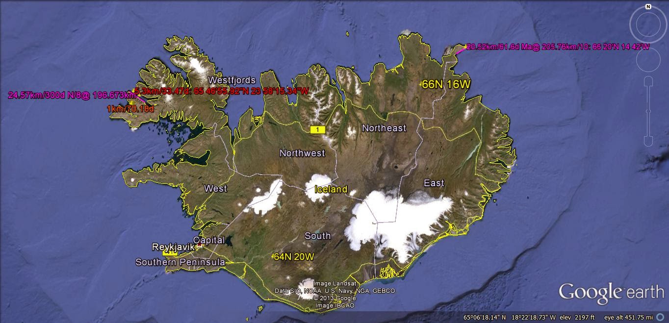
Iceland LOCATION, above, and INTERIOR ARCS. below:

NW corner, with ORBITAL INCLINATIONS, translated to distance= 111.111km/degree:

EXPANDED:

Hawaiian Islands, at the BIG ISLAND:

Below is shown my third analysis of the Hawaiian extrusions:


The age of Maui is known- being about 2 m.y. in age, and requires the location of the ORBITAL INCLINATIONS which were the IMPETUS of the development.
A surprise development from all of my analyses is the occurrence of linear gridlines near active geothermal entities. In the case of the Hawaiian chain, the grids occur in advance of the extrusions. This is also the case for the Garlock fault, the Aleutian spiral, and the east side of the Kuril Islands. I conclude from this that vulcanism and linear shear accompany each other. This is only seen for ocean basins and indicates that continental landmasses obscure the linears, preventing easy identification. I suspect that the evidence is there, but difficult to separate from other activities because of erosion, westward-moving protrusions (such as bulges, ranges, and individual mountains), and other competing events.
TRAPEZOIDAL ARRANGEMENT of ANALEMMA RISES and SINKS, due to Solar tides offsetting Lunar tides in the NE CORNER of CRUSTAL BLOCKS: The appearance of LINEARS- which are of limited distance EXTENT- is so common, that their exhibition must be explained as a general phenomenon: 1. Solar tides are continuous, whereas Lunar tides- although of greater magnitude- do not exert their influence similarly. Both tides are operating continuously, but the lunar gravitation sometimes adds to the solar tide, and sometimes subtracts from it. The literature reports that solar is less than half lunar, but the BINARY THEOREM (WHICH has contributed significant numerical prognostication) indicates that their magnitudes are 10.24 and 20.48 mm/year (and this works well for the Moon also).


Earth Dynamics have Three independent Forces
 1. EARTH TIDES;
2. CORIOLIS ROTATIONS, and,
3. intermittancy of the LUNAR GRAVITATIONAL-LATERAL SHOVE.
We will now re-analyze Hawaiian ROTATIONS, using the finding that there are ORTHOGONAL ROTATIONNS of 2 separate TIDAL RATES (E-W MOON and N-S SOLAR).
GPS movement indicator is shown below. Notice how there is drag on the block of CRUST, resulting in a rotation of sea-bottom between the transforms, and creating SHEAR, HEAT FROM BRITTLE ROCK FRICTION, AND VENTS in the process:


 Examples of C. include the obvious inflection of the Hawaiian-Emperor chain at the 41 m.y. age as it was deviated by the RISE OF THE SIERRAS, and subsequent tidal shove of the mountain bulge westward (SEE THE FIRST PHOTO SHOWN IN THIS BLOG ABOVE), and the portrait of Equatorial transforms in the Atlantic basin as they shear 300 miles or so (westward on the north side of the Equator) after the KT strike near Yucatan, Mexico:
All three of these entities are SOMEWHAT independent of each other (ALTHOUGH RELATED TO GRAVITATIONAL PHYSICS OR MECHANICS)- Lunar Friction, Earth surface velocity and Coriolis Force (combined with the inter-connected ANALEMMA creation), and Meteors from space- so that we have to sort out the results of these individual movements, as they are presented in Google Earth Photos. In the case of the Hawaiian chain, it is apparent that the orientation of the chain is not dominated by the northward movement of the Pacific Basin, as is shown in the following Photo:
The above photo shows that there is Coriolis spin, shear and HEAT development within the latitudes between the two E-W transforms shown (Maui to Baja and the Line Islands-Jalisco transforms).
The reasoning for the vector resultant shown on the HI diagram is determined by a divergence of the two tracks of rotating volcanoes, from the east side of the chain to the west,- GPS vector for the HI islands is NW, the Pacific Basin moves northward, and there is no subduction under the west coast of North America to the east of the large remaining islands (as shown by the coast of North America from 40N- Mt Lassen- to Jalisco, Mexico. This has previously been explained by the Plate Tectonics Theory, using the movement over Mantle Hotspots, while ignoring Coriolis Tectonics and Meteoric strikes. My assessment is that all of Earth movements noticed in landmasses (protruding continents and islands) arise from forces acting mainly on the Crust. Possibly we can sort all of these independently-acting forces by some obvious categorization.
the Equatorial bulge occurs in the 40N to 40S (subject TO GRAVITATIONAL RE-ADJUSTMENT BY SOLAR SYSTEM INFLUENCE) latitudes, and is expected to contrast with effects noticed in more distant-from-the Equator parallels. Thirdly, Meteoric strikes are randomly-occurring (ignoring cyclical comet events and periodicity of asteroids), and should be easily sorted out. The Line Islands orientation, and the drastic deviation along the Equator of E-W transforms in the Atlantic Ocean show that these obviously contrasting entities deviate from other events shown on Google Earth photos.
How to relate GPS vectors to earth dynamics, which show that Aleutian trends are SW, while the Pacific Basin moves northward (see the parabolic northward bulge in the collision zone near Denali- previously Mt. McKinley)? And how to square the northward movement (now) of the Pacific Basin with the Plate Tectonic theoretical movement of the HI Island northwestward (also now)? My intention is to use the finding for the Yellowstone track- roughly eastward- to determine what is happening with the Hawaiian track. The HI chain is a landmass, so I will categorize it in the same framework- it will be subject to the dominant factors moving the Yellowstone category.

GOOGLE PHOTO BELOW, OF THE MEEJI AND KIMMEI SEAMOUNTS ALLOWS A DETERMINATION OF THE ROTATION OF THE GREAT CELL THERE. NORTH OF THE MENDOCINO TRANSFORM, THE MOVEMENT IS TO THE EAST, WITH THE SOUTH SIDE TO THE WEST (SEE THE COASTLINE OF CA TO SEE THE DIFFERENCE IN MOVEMENT OF ABOUT 100 KM). THIS TRANSFORM CONTINUES TO THE LARGE CELL AT THE SEAMOUNT CHAIN, AND THE CELL THEREFORE IS ROTATING CCW. THIS REQUIRES THAT THE CHAIN, ON THE EAST SIDE, BE PROGRESSING TO THE SOUTH. SIMULTANEOUSLY, THE EQUATORIAL BULGE IS TERMINATING FURTHER TO THE SOUTH, AT 31N (COMPARED TO 40N LATITUDE AT MENDOCINO). THIS DOESN'T FIT WITH THE ASSERTION THAT THE PACIFIC PLATE IS MOVING NORTHWARD- MERELY THAT THE WHOLE ROTATION IS CREATING THE ILLUSION OF PLATE MOVEMENT.

THE GALAPAGOS ISLANDS LIE NEAR THE EQUATOR AND PROVIDE A LATITUDE WHERE THERE IS MINIMUM CORIOLIS ROTATION, NO LATITUDE CORRECTION, AND TERTIARY VULCANISM. IT IS INSTRUCTIVE TO MEASURE THE TIDAL MOVEMENT THERE, TO ELIMINATE SOME OF THE VARIABLES, AND TO MEASURE THE ACCURACY OF THE NORMAL 20MM/YR WESTWARD TIDAL SHIFT, BELOW IS THE ANALYSIS, USING ARCS AND THEIR ASSOCIATED ORTHOGONALS: DIAMETERS AND ROTATION ABOUT THE CENTER OF ARCS. NOTICE THAT THERE IS A GENERAL CCW ROTATION OF ARCS (THE RADIUS IS PROPORTIONAL TO AGE OF AN ARC, AND THE SHORTER, THE YOUNGER):


THE HUDSON BAY ANOMALY, WHICH IS DUE NORTH OF THE NEW MADRID QUAKE OF 1811 AND THE CHICXULUB EVENT IS AMPLIFIED TO SHOW THE SOLAR TIDAL RATE OF 10.24 MM/YR:

THE MAJOR 4 MULTIPLE EVENTS ARE SHOWN AT N, E, S, AND WEST CORNERS OF Qsna. THIS CREATES "ANALEMMAS". FIGURE 8S, AND RATIOS OF THE MILANKOVITCH CYCLES (1, 2.5, AND 4, FOR PRECESSIONAL, AXIAL, AND ELLIPTICAL ARCUATE CELLS).

PHOTO ABOVE DISPLAYS 3 SEPARATE SHEAR PATTERNS IN THE NE CORNER OF RISE TO SINK COMBINATION. THIS FEATURE HAS BEEN FOUND TO OCCUR WHENEVER THERE IS "JERKING" OF THE TRANSITION FROM SOLAR 10.24 TO LUNAR 20.48 KM/M.Y. TIDAL MOVEMENTS FOR A TRANSITION FROM A QUADRANT TO THE ADJOINING ONE ORTHOGONAL TO IT. THIS IS FOR SAND MOUNTAIN, WASHINGTON COUNTY, UT DOME AND SINK, BUT CAN PERTAIN TO A MUCH LARGER (OR SMALLER) GEOLOGICAL REGION.


NE corner triple “JERKS:
The northeast corners of individual orthogonal blocks incur changes from the SOLAR TIDAL MOVEMENT, of 10.24 to 20.48 mm/year in three stages. Although the changes appear to be random within a given block, e.g. Gulf of Mexico NE corner at DeSoto Canyon, overall for 5 cases there is a pattern: the changes in degrees are better viewed as fractions of the 360 degree circle for the earth. These are seen as 1/45, (8 degrees), 1/22.5, (16), 1/12, (30), 1/36, (10), 3/41, (26), 14/99, (51), 1/24, (15), and 1/15, (24).
These can be arranged as reciprocals of: 8, 10, 12, 15, 16, 22.5, 36, and 45. The last two categories are close to the Milankovitch cycles of 41 and 100 k.y. we can investigate whether there is a relationship between the change of magnetic period and the right-angle rotation of the CRUST relative to the MANTLE.


LEEDS VOLCANO, WHICH LIES JUST NORTH OF THE VIRGIN RIVER, UT, IS A YOUNG EXTRUSION WHICH DOES NOT YET BELCH THE 2ND BASALT (generally, 1 million years are required, for a top of the MANTLE EXTRUSION). THESE CRATERS ARE ALWAYS IN A BINARY ARRANGEMENT- EXTRUDING THE 2ND WITHIN 1 M.Y. AFTER COOLING AND GENERATING ADDED HEAT FROM BRITTLE FRICTION OF THE SINKING CRUST. THIS CRATER LIES AT AN INFLECTION IN THE NORMAL QUAIL ANTICLINE. IT GENERATED HEAT VIA THE GOUGE CREATED BY THE MOVEMENT WESTWARD OF EARTH TIDES. THE SOLAR TIDE OF 10.24MM/YR IS OFFSET BY THE ADDED WESTERN LUNAR TIDE OF 20.48. WHENEVER THE BEND IN THE ANTICLINE (INFLECTION) IS CONVEX TO THE EAST, THE SOLAR TIDE OPENS THE CRUST VIA THE LARGER WESTWARD LUNAR TIDE OF 20.48MM/YR. THIS CASE MAY NOW BE USED TO EXPLORE THE LARGER PHENOMENON OF SUTTER BUTTES, CA- WHICH IS ALSO A SINGLE MASS, AND NOT YET A BINARY PAIR OF VOLCANOES. NOTICE THAT THE ENTITY RESULTS FROM THE OPENING IN THE CRUST, CREATED BY THE INFLECTION IN THE ANTICLINAL TREND. THIS MAY NOW BE COMPARED WITH THE TREND OF THE SIERRAS VS. THE MENDOCINO NW (45 DEGREES) TREND CREATING AN INFLECTION, HEAT OF FLEXURE OF THE CRUST AND POSSIBLY THE GEYSERS GEOTHERMAL AREA.
Above is an Analemma for the Pacific Ocean to the North
American continent. Although I have found that the arrangement of these FIGURE 8’s is universal (for the entire globe) due to the daily and yearly influence of the SUN and Venus, the sketch is subjective. I try to follow borders, creeks, and curvilinears in the ocean, but there are quite a lot of other possible interpretations.

After viewing the entire circuit of the INNER CIRCLE of Qsna, we find several new revelations:
a. What appeared to be an error turns out to be the “HORNS” of an Analemma. The diversions near Bermuda and the Aleutian Spiral, AK are new disclosures about the gravitational arrangement of Qsna in an two-part circular division of the ELLIPSE into a larger oval to the north and a smaller PRECESSIONAL CELL to the south. The RATIO of the diameters is very near 1.62, and the error of my work is shown by the diameter of the northern portion being very near to the SKETCH I made of the rotation about the main land mass of Qsna. The binary theorem anticipates that this ratio should be 1.6 (40/25), and I can’t yet find which is more likely correct. Unknown magnetic, electrical, or extra-solar system influences my cause the measured entities such as EXTENSION AGES and Milankovitch cycles to entail errors;
b. Axial cells are usually flat-and-level rises, while PRECESSIONAL cells are fractured or dipping; the appearance of the main mass of Qsna north of the DIVIDER would be in this AXIAL category. While it is true that most of the upper cell is in the Canadian Shield, there are the Rockies in western Canada and the Inner Passage metamorphic outcrops; and,
c. the Precessional cell portion includes the Midwest and SW USA- which contains many mountain ranges and uplifts. While these have ranges parallel to the divider (the so-called WASATCH LINE), they necessitate another categorization for identifying a tilted-and-changing POLAR TILT.
The idea is correct, and the ANALEMMA is proving to be almost OMNI-PRESENT, but the use of this is merely instructive. However, for the case of the PARIA PLATEAU below, the subjectivity is much less; the proof (to me) lies with the ratio of the two borders’ distances. This ratio is always nearly 1.6, and the ratio of Orbit days for the EARTH/VENUS, is 1.62, according to astronomers. These linear borders are always slanted with respect to one another, with one of them orienting E-W. Within the two borders occur two or more separate features: a flat-and-level circular feature with a dimension of 8, and a tilted partial circle entity with a dimension of 5. The ratio of these two is 1.6, and I cannot measure any closer- although I expect that the ratio 1.62 is more appropriate. Milankovitch’s AXIAL/PRECESSIONAL CYCLES have a ratio of 41/24+, and the divisor is a variable- according to the variable precessional wobble of the poles (20.5 to 24.5 degrees tilt of the poles). Using 41/25.3 for past tilts, the ratio is 1.62. This investigation is on-going, and I will try to improve its accuracy, but the idea is so repetitive, that it cannon be ignored!

Below is the Rocky Mountain ARCHIPELAGO- which is difficult to determine from this mostly-distorted 100+ m.y. chain (due to subsequent TITS jutting E-W, and coves moving oppositely in smaller arcuate exhibits).

Difficult to see on this photo (I don't DARE ELIMINATE any of this information- requiring 5 years of work to develop), is the WAVE PROGRESSION of the EARLY FORERUNNERS of the present chain. If you don't have cataracts, you may be able to discern the patterns:


All this is valuable for determination of ELAPSED TIMES of developing arcs- which determine THRUST FAUTING OCCURRENCE, RATES, Times of POLAR WOBBLE ANGLE SHIFT, SEPARATION of OCEANIC TRANSFORMS, RIVER PATHS, and Geothermal activities- such as HOT SPRINGS, VOLCANICS, and SOLUBILITY-CHANGING dissolved CHEMICALS in ground water, producing SLICKENSIDES. GEOPRESSURE is related to movements also, since the wide areal slip of SHALE BLOCKS under the IMPETUS of rotating SEDIMENTARY COLUMNS creates the HIGH PRESSURE GRADIENTS:


ABOVE IS THE PARIA PLATEAU, FROM THE VERMILION CLIFFS, NEAR THE COLORADO RIVER, TO THE NORTHERN BORDER. THIS CONTAINS ALL THE FAMOUS GULCHES (BUCKSKIN, PARIA RIVER, AND WIRE PASS), AS WELL AS THE "WAVE" FOUND BY GERMAN PHOTOGRAPHERS- NOT AMERICAN GEOLOGISTS. THE ENTRANCE IS SHOWN BELOW, AND ONLY 20 HIKERS/DAY ARE ALLOWED- IN ORDER TO PROTECT THESE SENSITIVE DUNE SAND LEDGES, FOLDS, AND CIRCULAR ROTATIONS OF THE VARIOUS CREEKS (OPENINGS ROTATING BOTH VERTICALLY AND HORIZONTALLY):


LEEDS VOLCANO HAS 2 SEPARATE DOMES WHICH WERE BELCHED BOTH WITHIN A FEW THOUSAND YEARS; THESE ARE MARKED BY A DIVIDING LINEAR, WHICH IS THE LOCATION OF THE ORIGINAL LINE SEPARATING THE SOLAR EAST TIDES FROM THE LUNAR WEST TIDES. I AM EXPLORING THIS FEATURE, WITH THE INTENT TO FIND WHETHER THE LINEAR OPENED THE CRUST ALL THE WAY TO THE MANTLE- ALLOWING NORMALLY HOT BASALT TO SIMPLY EMERGE BY BUOYANT RISE OF THE LIGHT MAGMA. THIS IS THE SIMPLEST CASE WHERE BASALT RISES UPON ENCOUNTERING AN OPENING (PIPE OR CONDUIT) TO THE ATMOSPHERE. THE DIVIDING LINEAR WOULD NOT BE A CURVILINEAR, BUT WOULD BE A LIMITED EXTENT LINEAR, CREATED BY THE 45 DEGREE TURN TO THE LEFT OF THE VIRGIN ANTICLINE (CORRELATED WITH THE 2 M.Y. ELTANIN EVENT OR LATER):

THIS IS SHOWN IN OBLIQUE VIEW, SO AS TO ALLOW A 3D ANALYSIS.

ANALYSIS of the 41 m.y. EVENT, DISPLAYED in many OUTCROPS The first notice of the 41 m.y. was found in the Kimmei Seamount- a fulcrum of the rotation of the HI-Emperor Chain. The rotation of the chain at that point is not precise, and the 45 degree turn takes a few million years to make the transition of the N-S chain to one of roughly NW-SE orientation. This slow transition seems to be typical of these earth movements- where the PTr, or Permian-Triassic transition, (which left most fossils absent in the Triassic) required a few million years to allow the Petrified remains of trees to become obvious. Later, it was noticed that the calculated 41 m.y. event was found in the Aleutian Spiral, the Central American curlicue, the rise of the Sierras, the initiation of basaltic extrusion in the llano Quemado (Taos, NM), and the start of over-ride of the Olympic Peninsula. The 40N latitude Mendocino TRANSFORM connects with the large rotation at the Kimmei seamount, and this slice has replicated itself many times- calculated to have occurred since 192 m.y. AGE. There are as many as 5 slices parallel- roughly- to each other (these become fainter with time, and probably have presented 100 slices (4.096b.y./40.96 m.y.per cycle= 100). The 41 m.y event is related to the change of the angle of the EQUINOX, from a smaller magnitude to that near the present 23.5 degrees, by the relation: 1/100th of the earth circumference of 40,000 km= 400, plus extra at BULGES. This is near the 420 km- measured at the GAKKEL-LOMONOTOV separation). There is still doubt as to the applicability of the number 41, compared to 40.96 m.y., as would be indicated by the BINARY THEOREM. The hundredth harmonic of the series: .02, .04, 08, .16, .32, .64, 1.28, 2.56, 5.12, 10.24, 20.48, and 40.96 indicates that this should be the magnitude of such cycles as the MILANKOVITCH AXIAL ROTATION (k.y.), and the age of the MOON- 4.096 b.y. since the measured radioactivity AGES of such events as KT (65 m.y.) and PTr (251) have a less than 4% variation from the BINARY THEOREM (64 and 256 m.y.). I take this to be departures due to non-gravitational influences. These could be due to magnetic-electrical, thermal, or extra-SOLAR event, and I have made NO DETERMINATION of the one which is pertinent to GRAVITY ALONE. WE CAN EXPLORE the pertinence of both by use of RATIOS, such as the EARTH/VENUS ORBITAL CYCLES (days/year)= 1.62, from calculation, and from ccw features/cw rotations of crust- such as ANALEMMAS shown by the Aleutian Spiral, DAILY WEATHER LOW/HIGH PRESSURE CELLS, or by measured diameters of CP/B&R ARCUATE FEATURES in the EARTH’S CRUST. I have measured both 1.6 and 1.62, so that the evidence presents a MIXED BAG. CALCULATIONS YIELD: 40 k.y. AXIAL WOBBLE/25 k.y. PRECESSIONAL= 1.6, but the Precessional angle varies over a cycle from 21.5 to 24.5 degrees (literature reported), so that 40/21.5= 1.86, to 40/24.5= 1.63. The present calculation is: 40/23.5= 1.70- which yields NO CONCLUSION! ALTERNATIVELY, 40.96/21.5= 1.9; 40.96/24.5= 1.67, and these are close to: 41/21.5= 1.907; 41/24.5= 1.673. it appears that the RATIO 1.63, for 40,000/25.5 k.y. is closest to the 1.6 ratio I get from GOOGLE EARTH, so that I will continue to amass data which is measured, and NOT CALCULATED! Below is that for the COLORADO PLATEAU/BASIN and RANGE:


CENTRAL AMERICA is the SOUTHERN TRANSITION of LATERAL GRAVITATION MOVEMENT for the North American (CCW rotating) QUADRANSPHERE, Qsna:


(NOTICE in the large view photo, that there is a LINEAR DIVIDING an 80 m.y. from a 157.5 m.y. FEATURE. This indicates the error of this type of ANALYSIS! It should be 80 and 160 m.y., ACCORDING to the BINARY THEOREM! The SOLAR PORTION SHOULD BE A HALF of the LUNAR PORTION- THIS IS A 1%+ ERROR!).
There is no information for the CCW rotation from Hawaii to the west coast of Guatemala, and for the Atlantic Ocean from the Puerto Rican trench to the Mid-Atlantic Ridge, MAR. These regions are called GAPS, BECAUSE of the paucity of data which can be translated into the general analysis.Some inferences can be made for the Atlantic portion- from features shown subsea, but the East Pacific is so deep, that conclusions are lacking SE of the EARTH TIDAL changes shown for the SE block off the big island of Hawaii. These GAPS are now known to be similar to the valleys between linear mountain ranges in the CW Precessional cycles of the ANALEMMA for the Colorado Plateau-Basin and Range, CP-B&R, Province. The analemma, created by the gravitational arrangement by the EARTH-MOON-SUN is the dominating factor for the whole earth, and it has harmonics at smaller scales- one of which is the Kimmei seamount to HI line. The analemma for the whole earth is subtle, and does not exhibit the 1.62 ratio of diameters of AXIAL/PRECESSINAL CIRCLES normally calculated, but is found from the PEAR BULGE (an added amount for the diameter) of the South Pacific Ocean islands- compared to the slightly smaller diameter forthe rest of the globe.

Solving the various GRAVITATIONAL LATERAL and VERTICAL MOVEMENTS requires that a simple case of known GEOLOGY (field familiarity) be documented. (see attachments):


1.The older MOGOLLON RIM- which rotates CCW (same as the CP, along which the rim rotates) drags the adjacent CRUST in a CCW movement. This is simultaneous with a “LIPPING” up of the rim, so that drainage is to the NW, except for canyons which are due to later MILANKOVITCH ROTATIONS (smaller diameters);

2.This creates ELLIPSES, and later ANALEMMAS- which have both rises and sinks. I can see the double radius, but the separation along a WASATCH LINE is subtle. These develop adjacent to the rim, where the maximum DRAG OCCURS;

3.This action occurs younger than the RIM, and continues in “JERKS”. THE CCW ROTATION creates RISES, and GOOGLE EARTH allows the elevation to be measured. The jerks are in groups of 16, and then a larger phenomenon occurs- a canyon or thermal event is developed. The circular development of the ellipse creates both lateral and vertical shear (uplift or a RISE);
4.After several episodes, a complete circular shearing develops to the north (this should be checked for sinking to the south, and the Tonto Park should be checked to confirm). After 10 shearing actions, the Meteor Crater drops. I can see several different diameter arcs in the lip, but not 10- which is the indicated number (2.5m.y./10x4= 62.5 k.y.). The NUMBER 4- in the BINARY THEOREM of 4, 16, 64, 256 up to 1-024 m.y. series- occurs WHENEVER GRAVITATIONAL DESTRUCTION TRANSPIRES (CRUST is REMOVED in this case- compare to the major GREAT UNCONFORMITY in the GRAND CANYON, for the 1.024 b.y. ejection of a half billion years of deposition); and,

5. This represents a VERTICAL LOOP of TRANSFER of mass from the crater to the ELLIPTICAL RISE, near the Mogollon Rim (a 3D circulation in a N-S DIRECTION). Possibly the MATH is simple for you!

The North American Quadransphere can be viewed as a landmass, with inflections at important ANOMALOUS STRUCTURAL DEVIATIONS (angular turns at coastlines). This is shown below, with the 12+ 1777 km SEGMENTS shown in detail:

Why are there 12 INFLECTIONS (with many smaller ANOMALIES), OTHER THAN THE GRAVITATIONAL MOON-SUN REARRANGEMENTS? The first question I asked regarded that the number could be an INDICATOR! JUPITER has its ORBIT 12x the earth's, but this largest planet is still less important than SUN, MOON, VENUS, and possibly MARS! The number 1777 is broken down as follows:
1. Assume that I made an ERROR, and that 1800k is more likely the MAGNITUDE which would yield exactly 12 segments. I tried this and the ERROR WAS LARGER!

SO FAR, I DON'T HAVE A SOLUTION TO THE 1777 km length SEGMENT OCCURRENCE, but further math analysis will yield CLUES;

No. 2 above is the CENTRAL AMERICAN ROTATION, and No 3, below is located OFFSHORE COSTS RICO:

 No. 4 lies near the GUF STREAM OFF FLORIDA KEYS, and No. 5 is adjacent to Long Island:
 Lawrence, and N0. 7 is south of Byam Martin I. north of the NW Passage:

No. 9 exhibits a SW TURN towards Alaska:

No. 10 is the last of the peninsula, before the Aleutian Islands:

Finally, No. 11 is at the major inflection NW of the PANHANDLE. Altogether there are 12 segments- the same as the YEARLY EARTH-MOON CYCLE. There is a 236 km GAP, before reaching Mendocino, and this could be due to my presonal error, or more likely due to the EXTRA DAYS in the LUNAR CYCLE of 365.24/29= 12.5 ORBITAL DAYS:


ARC ANALYSIS is not definitive, use the POLYGON ANALYSIS!

BINGO! This quarter of a POLYGON- 20 sided- yields not only an AGREEABLE AGE (36 m.y. similar to neighboring TIME INTERVALS), but a VOLCANIC-PRODUCING LINEAR- the Cerro Prieto GEOTHERMAL AREA, which I visited with Dr. Blair of Las Alamos Q section 30 years ago. We were CATEGORIZING GEOTHERMAL AREAS for use with the HOT DRY ROCK PROJECT of Fenton Hill, NM. Now we have an EDGE into understanding the Sutter Buttes Pleistocene basaltic EXTRUSIONS in the Central Valley, CA:
RATIOS of Inclination angles, in the Equations: (R- 1)= I index.
The ratios of the Major Planetary INDICES seem to be related:
Ma/U= 2.39568; S/N= 1.4091, and S/N + 1 = Ma/U (with a .5% difference), or (2.49424/1.77006) + 1= (1.40913)+1= 2.40912737; Ma/U= {1.851819/,7729813} = 2.395684, which yields a .6% difference!
CONCLUSION: Ma/U= S/N + 1! Checking for others:
Me/Ma (7.006/1.851819)= 3.7833 = Me/S (7.006/2.49424)of 2.8089 has -1 difference, within 2.6%;
V/Ma= 1.83483 vs. Me/S= 2.80887= 7.006/2.49424 (1- within 2.6%);
Me/N= 2.809 vs. V/Ma= 1.835, with .965 difference;
Pl/Me= 2.448 vs. Ma/J= 1.42, with 1.048 difference; Pl/V= 5.045 vs. Me/N= 3.9578, with 1.087 difference. DIFFERENCES are getting LARGER, and ALL Planets except Jupiter fit the 1+ relation;
Jupiter has its own Inclination FITTING a separate CATEGORY: Inclination=1.305 degrees, which is near the S/N 1.4091 ratio, and +1 to N/U= 2.29 (.985 difference). Ma/J= 1.42 vs. Mw/V= 2.396, with D=.976
The Ma/U, S/N sequence has the smallest variation from the unit 1, and requires analysis. The Neptune and Uranus duo have a LOCKED set of Orbits, where 164.79/84.02 years = 1.96132 ratio (159/81= 1.963, {or 639/325= 1.966, or 1279/652= 1.961656} and 17.24/16.11 hours= 1.070 [14/13= 1.077, or 224/209= 1.0718].
(Ma/U -1)= S/N equation can be REARRANGED to (Ma/U-1)/S/N= 1, or (Ma/U/S/N)- N/S= 1, or MaN/SU- N/S= 1, which isolates the term MaN/SU as significant. These Planets are Gaseous, with Mars as the exception! MaN/SU= 1.851819 x 1.77006)/{2.49424 x .7729813}= 1.70= 1/.58819. The number 1.7 occurs with Pluto’s 17 degree Inclination, with Neptune’s 1.77d, and with J/U= 1.305/.7729813= 1.68827, approximately! Further, U + 1= 1.77298, which is near Neptune’s 1.77006d Inclination. Considering that there ALWAYS OCCUR unknown aberrations, such as with Magnetic and Thermal influences, the (1 + RATIOS) EQUATION appears useful. I will explore the possibility that the Planets are governed by GRAVITATIONAL RULES which are additional to the known M1xM2/separation squared Newtonian equation.
Google Earth calculations have shown that the RATIO 1.7777= 40,000km/360 degrees explains several MEASUREMENTS, such as the series of 1777 km SEGMENTS surrounding the North American QUADRANSPHERE, Qsna. MULTIPLES of 1.7 are becoming IMPORTANT!

